alb5405608
Joan Blaeu, The Netherlands, 17th Century
| Share |
|---|
 Pinterest Pinterest |
 Twitter Twitter |
 Facebook Facebook |
 Copy link Copy link |
 Email Email |
|
Add to another lightbox |
|
Add to another lightbox |


Title:
Joan Blaeu, The Netherlands, 17th Century
Caption:
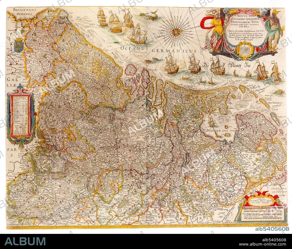
The Netherlands is a country located mainly in Northwestern Europe. Together with three island territories in the Caribbean (Bonaire, Sint Eustatius and Saba), it forms a constituent country of the Kingdom of the Netherlands. The European portion of the Netherlands consists of twelve provinces and borders Germany to the east, Belgium to the south, and the North Sea to the northwest, sharing maritime borders in the North Sea with Belgium, the United Kingdom, and Germany. Joan Blaeu (1596-1673) was a Dutch cartographer, the son of cartographer Willem Blaeu. In 1635 they published the Atlas Novus (full title: Theatrum orbis terrarum, sive, Atlas novus) in two volumes. The Atlas Maior is the final version of Joan Blaeu's atlas, published in Amsterdam between 1662 and 1672, in Latin, French, Dutch, German and Spanish, containing 594 maps and around 3,000 pages of text. The Blaeu maps emphasized fine art and colours, being the most expensive of the time.
Credit:
Album / Science Source
Releases:
Model: No - Property: No
Rights questions?
Rights questions?
Image size:
4200 x 3363 px | 40.4 MB
Print size:
35.6 x 28.5 cm | 14.0 x 11.2 in (300 dpi)
Keywords:
1600S • 17TH CENTURY • 17TH • AGE • ÂGÉS • ATLAS • BLAEU • CARTOGRAPHIC • CARTOGRAPHICAL • CARTOGRAPHY • CELEBRITY • CENTURY • DUTCH / NETHERLANDISH • DUTCH • EUROPE • FAMOUS • GEOGRAPHIC • GEOGRAPHICAL • GEOGRAPHY • GOLDEN • HISTORIC • HISTORICAL • HISTORY • IMPORTANT • INFLUENTIAL • JOAN • MAKING • MAP MAKING • MAP • MAP-MAKING • MAPMAKING • NETHERLANDS • NORTHWESTERN • NOTABLE • NOVUS • OF • OLD • SEVENTEETH • WELL-KNOWN
