alb4450932
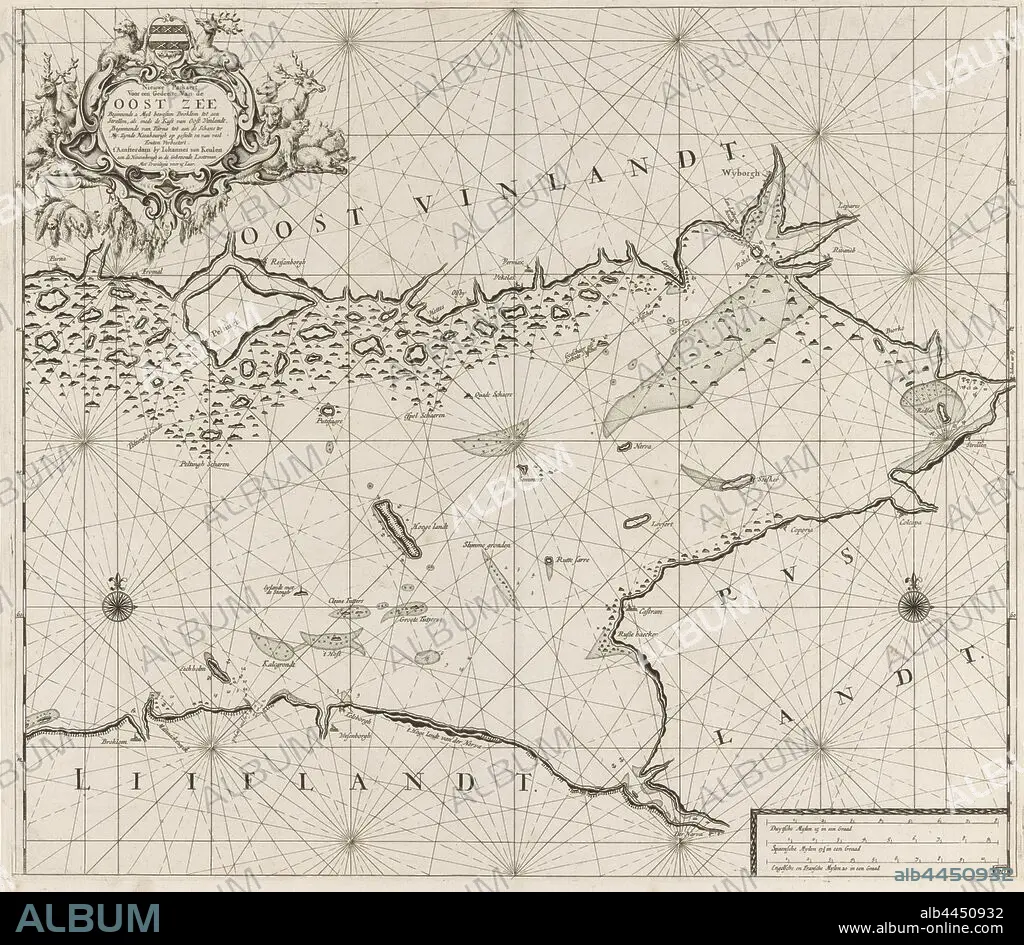
Map of the eastern part of the Gulf of Finland New pass for part of the Baltic Sea starting from 2 Myl west Broklom to a and Strellen, as well as the Coast of East Vinlandt, starting from Parna to the Schans ter Ny. Zynde Naeukeurigh on systems and many errors Verbeetert. (title on object), Map of the eastern part of the Gulf of Finland, with two compass roses, the North is above. Above left a cartouche with the title and address of the publisher, decorated with a weapon, deer, bears and seals. Bottom right the scale in German, Spanish and English or French miles (scale: c. 1: 400 000), beasts of prey, predatory animals: bear, hoofed animals: deer, swimming mammals: seal, Baltic Sea area, Jan Luyken (possibly), Amsterdam, 1681 - 1799, paper, engraving, h 520 mm × w 585 mm.
| Compartir |
|---|
 Pinterest Pinterest |
 Twitter Twitter |
 Facebook Facebook |
 Copiar enlace Copiar enlace |
 Email Email |
|
Añadir a otro lightbox |
|
Añadir a otro lightbox |


¿Ya tienes cuenta? Iniciar sesión
¿No tienes cuenta? Regístrate
Compra esta imagen.
Selecciona el uso:

Descripción:
Ver traducción automática
Map of the eastern part of the Gulf of Finland New pass for part of the Baltic Sea starting from 2 Myl west Broklom to a and Strellen, as well as the Coast of East Vinlandt, starting from Parna to the Schans ter Ny. Zynde Naeukeurigh on systems and many errors Verbeetert. (title on object), Map of the eastern part of the Gulf of Finland, with two compass roses, the North is above. Above left a cartouche with the title and address of the publisher, decorated with a weapon, deer, bears and seals. Bottom right the scale in German, Spanish and English or French miles (scale: c. 1: 400 000), beasts of prey, predatory animals: bear, hoofed animals: deer, swimming mammals: seal, Baltic Sea area, Jan Luyken (possibly), Amsterdam, 1681 - 1799, paper, engraving, h 520 mm × w 585 mm
Crédito:
Album / quintlox
Autorizaciones:
Modelo: No - Propiedad: No
¿Preguntas relacionadas con los derechos?
¿Preguntas relacionadas con los derechos?
Tamaño imagen:
6394 x 5572 px | 101.9 MB
Tamaño impresión:
54.1 x 47.2 cm | 21.3 x 18.6 in (300 dpi)
Palabras clave:
1 • 1681 • AGUAFUERTE • ALEMAN • ALEMANA • ALEMANES • AMSTERDAM • ANIMALES DEPREDADORES • ARMA GRIEGA • ARMA • ARMAS • BRITANICO • BRITANICOS • CERVIDO • CIERVO • COSTA • DECORADA • DECORADO • DEER • EDITOR • ENGRAVING • ESCALA • ESPAÑOL • ESPAÑOLA • ESPAÑOLES • FIERAS • FINLANDIA • GOLFO • GRABADO • GRABADOS • INGLES • INGLESA • INGLESES • IZQUIERDA • JAN LUYKEN • MAPA • NORTE • OBJETO • OSO • PAPEL • PARTIDA • POZO • PRESA • SEALS • SISTEMAS DE, LOS • SISTEMAS • WEAPON
