alb3547306
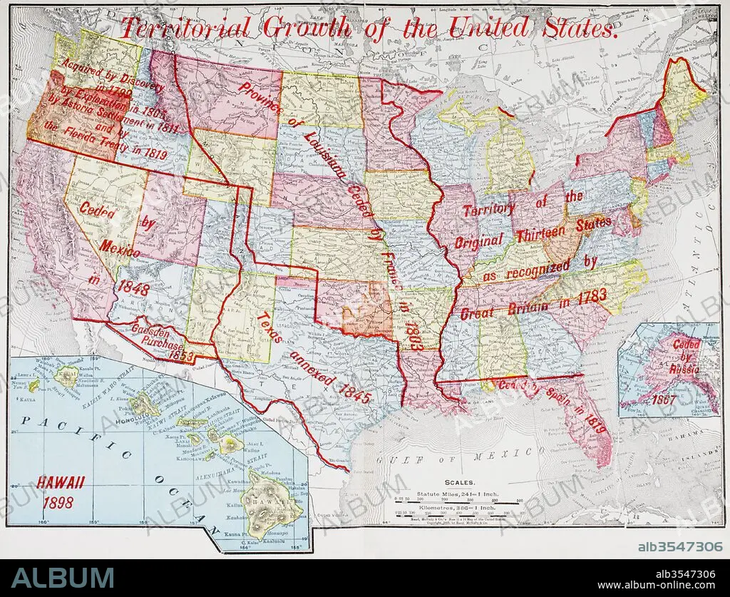
Map from 1898 showing the territorial growth of the United States of America
| Compartir |
|---|
 Pinterest Pinterest |
 Twitter Twitter |
 Facebook Facebook |
 Copiar enlace Copiar enlace |
 Email Email |
|
Añadir a otro lightbox |
|
Añadir a otro lightbox |


¿Ya tienes cuenta? Iniciar sesión
¿No tienes cuenta? Regístrate
Compra esta imagen.
Selecciona el uso:

Título: Map from 1898 showing the territorial growth of the United States of America
Descripción: Ver traducción automática
Map from 1898 showing the territorial growth of the United States of America. From The History of Our Country, published 1900
Map from 1898 showing the territorial growth of the United States of America. From The History of Our Country, published 1900
Crédito: Album / Universal Images Group / Universal History Archive
Autorizaciones: ? Cesión de modelo: No - ? Cesión de propiedad: No
¿Preguntas relacionadas con los derechos?
¿Preguntas relacionadas con los derechos?
Tamaño imagen: 4783 × 3664 px | 50.1 MB
Tamaño impresión: 40.5 × 31.0 cm | 1883.1 × 1442.5 in (300 dpi)
Palabras clave: 1898 • ALASKA • AMERICA • AMERICAN • AMERICANA • AMERICANO • AMERICANOS • AMERICAS • AMERICAS, LAS • ANEXION • BRITANICA • BRITANICO • BRITANICOS • CONTINENTE AMERICANO • CRECIMIENTO • DANES • DANESA • DINAMARCA • EE. UU • EE. UU. • EEUU / ESTADOS UNIDOS • EEUU • ESPAÑA • ESPAÑOL • ESPAÑOLA • ESPAÑOLES • ESTADOS UNIDOS DE AMERICA • ESTADOS UNIDOS • ESTADOUNIDENSE • ESTADOUNIDENSES • FRANCES • FRANCIA • GEOGRAFIA • GEOGRAFICO • GRAFICO • GRAN BRETAÑA • HISTORIA • HISTORICO • ILUSTRACION • ILUSTRACIONES • INGLATERRA • LUISIANA • MAPA • MAPAS • MEJICO • MEXICANO • MEXICO • NORTEAMERICANA • NORTEAMERICANAS • NORTEAMERICANOS • ORIGINAL • PAÍS • REINO UNIDO • REINO • RUSA • RUSIA • RUSO • RUSOS • S. XIX • SIGLO XIX • SIGLO • SPAIN • TERRITORIO • TEXAS • TRECE • U. S. A. • USA
