alb3825656
Geology of Hawaiian Islands, illustration
| Compartir |
|---|
 Pinterest Pinterest |
 Twitter Twitter |
 Facebook Facebook |
 Copiar enlace Copiar enlace |
 Email Email |
|
Añadir a otro lightbox |
|
Añadir a otro lightbox |


¿Ya tienes cuenta? Iniciar sesión
¿No tienes cuenta? Regístrate
Compra esta imagen.
Selecciona el uso:

Título: Geology of Hawaiian Islands, illustration
Descripción: Ver traducción automática
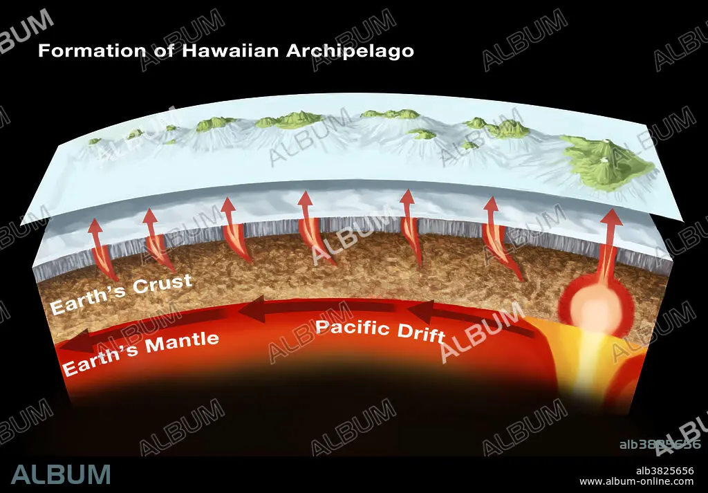
The geology of the Hawaiian Islands. This illustration shows the archipelago and underwater topography of the Hawaiian Islands. These volcanic islands, located in the northern Pacific Ocean, have formed as volcanoes rising from a mantle hot spot under the sea floor some 5500 meters below sea level. There are eight main islands (as pictured here): Big Island (Hawaii Island), Maui, O'ahu, Kaua'i, Moloka'i, Lana'i, Ni'ihau, and Kaho'olawe. The highest point is the peak of the Mauna Kea volcano (on Big Island), at 4205 meters elevation.
The geology of the Hawaiian Islands. This illustration shows the archipelago and underwater topography of the Hawaiian Islands. These volcanic islands, located in the northern Pacific Ocean, have formed as volcanoes rising from a mantle hot spot under the sea floor some 5500 meters below sea level. There are eight main islands (as pictured here): Big Island (Hawaii Island), Maui, O'ahu, Kaua'i, Moloka'i, Lana'i, Ni'ihau, and Kaho'olawe. The highest point is the peak of the Mauna Kea volcano (on Big Island), at 4205 meters elevation.
Crédito: Album / Science Source / Spencer Sutton
Autorizaciones: ? Cesión de modelo: No - ? Cesión de propiedad: No
¿Preguntas relacionadas con los derechos?
¿Preguntas relacionadas con los derechos?
Tamaño imagen: 3903 × 2514 px | 28.1 MB
Tamaño impresión: 33.0 × 21.3 cm | 1536.6 × 989.8 in (300 dpi)
Palabras clave: ANOTADO • ARCHIPIÉLAGO • ARTE • CIENCIA • CORTEZA • DERIVA • DIAGRAMA • FLOTA • GEOGRAFIA • GEOGRAFICO • GEOLOGIA • GEOLOGICO • GRÁFICOS • GRANDE • HAWAIANA • ILUSTRACION • ILUSTRACIONES • INFOGRAFÍA • INFOGRAFÍAS • ISLA • ISLAS • MAR • MARINA • MARINE • MAUI • OBRA DE ARTE • OCEANO • PLANETA TIERRA • SEA • TOPOGRAFIA • TOPOGRÁFICOS • VOLCAN
