alb9203323
Water Stress by 2040, Map
| Compartir |
|---|
 Pinterest Pinterest |
 Twitter Twitter |
 Facebook Facebook |
 Copiar enlace Copiar enlace |
 Email Email |
|
Añadir a otro lightbox |
|
Añadir a otro lightbox |


¿Ya tienes cuenta? Iniciar sesión
¿No tienes cuenta? Regístrate
Compra esta imagen.
Selecciona el uso:

Título:
Water Stress by 2040, Map
Descripción:
Ver traducción automática
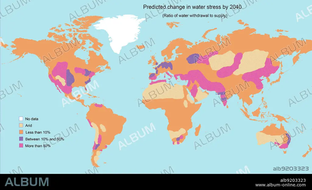
A map showing the predicted change in water stress (the ratio of water withdrawal to supply) by 2040. The areas of greatest stress are roughly indicated in bright purple. They include the western USA and Central America, southern Europe, the Middle East and parts of Asia, Northern Africa, South Africa, and parts of Australia and South America. Data adapted from the World Resources Institute.
Crédito:
Album / Jessica Wilson / Science Source
Autorizaciones:
Modelo: No - Propiedad: No
¿Preguntas relacionadas con los derechos?
¿Preguntas relacionadas con los derechos?
Tamaño imagen:
No disponible
Tamaño impresión:
No disponible
Palabras clave:
ABASTECER • ABASTECIMIENTO • AGUA • CALENTAMIENTO • CLIMA • DESIERTO • DIAGRAMA • ECOLOGIA • ECOSISTEMA • EDUCACION • ESCASEZ • ESTRES • FRIO • FUTURO • GEOLOGIA • GLOBO • HIELO • HÚMEDO • INFOGRAFÍA • MAPA • MEDITERRANEO • MUNDIAL • MUNDO • PLANETA TIERRA • PORCENTAJE • PREVISION • RECLAMO • SUMINISTRO DE • SUMINISTRO • TACHADO • TEMPLADOS • TIERRA • TROPICAL • TUNDRA • ZONAS
