alb9878434
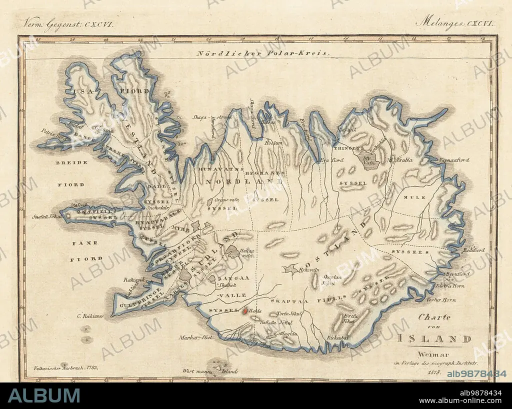
Map of the island of Iceland, 1815. With the town of Reykjavik, volcanic mountains of Hekla, Krafla, Skaftafell, Eyjafjallajökull, etc. Copied from an illustration by cartographer Carl Ferdinand Weiland of Weimar, Verlage des Geograph Instituts, 1815. Handcoloured copperplate engraving from Carl Bertuch's Bilderbuch fur Kinder (Picture Book for Children), Weimar, 1815. A 12-volume encyclopedia for children illustrated with almost 1,200 engraved plates on natural history, science, costume, mythology, etc., published from 1790-1830.
| Compartir |
|---|
 Pinterest Pinterest |
 Twitter Twitter |
 Facebook Facebook |
 Copiar enlace Copiar enlace |
 Email Email |
|
Añadir a otro lightbox |
|
Añadir a otro lightbox |


¿Ya tienes cuenta? Iniciar sesión
¿No tienes cuenta? Regístrate
Compra esta imagen.
Selecciona el uso:

Descripción:
Ver traducción automática
Map of the island of Iceland, 1815. With the town of Reykjavik, volcanic mountains of Hekla, Krafla, Skaftafell, Eyjafjallajökull, etc. Copied from an illustration by cartographer Carl Ferdinand Weiland of Weimar, Verlage des Geograph Instituts, 1815. Handcoloured copperplate engraving from Carl Bertuch's Bilderbuch fur Kinder (Picture Book for Children), Weimar, 1815. A 12-volume encyclopedia for children illustrated with almost 1,200 engraved plates on natural history, science, costume, mythology, etc., published from 1790-1830.
Personas:
Crédito:
Album / Florilegius
Autorizaciones:
Modelo: No - Propiedad: No
¿Preguntas relacionadas con los derechos?
¿Preguntas relacionadas con los derechos?
Tamaño imagen:
6643 x 4961 px | 94.3 MB
Tamaño impresión:
56.2 x 42.0 cm | 22.1 x 16.5 in (300 dpi)
Palabras clave:
1815 • AGUAFUERTE • CARL BERTUCH • CARTOGRAFO • CHICA • CHICO • CHICOS • CIENCIAS NATURALES • COLOREADO A MANO • CORDILLERA • EDUCACION • ENCICLOPEDIA • ENGRAVING • GEOGRAFIA • GRABADO • GRABADOS • GRAFICO • HISTORIA NATURAL • ILUSTRACION • ILUSTRADO • ISLA • ISLANDIA • ISLAS • JOVEN • JUVENTUD • MACIZO • MAPA • MUCHACHA • MUCHACHOS • NIÑA • NIÑO • NIÑOS • PLATO DE COBRE • PUEBLO • REIKIAVIK • VOLCAN • WEIMAR
