alb11639028
Arctic ice minimum extent, 2024
| Compartir |
|---|
 Pinterest Pinterest |
 Twitter Twitter |
 Facebook Facebook |
 Copiar enlace Copiar enlace |
 Email Email |
|
Añadir a otro lightbox |
|
Añadir a otro lightbox |


¿Ya tienes cuenta? Iniciar sesión
¿No tienes cuenta? Regístrate
Compra esta imagen.
Selecciona el uso:

Título:
Arctic ice minimum extent, 2024
Descripción:
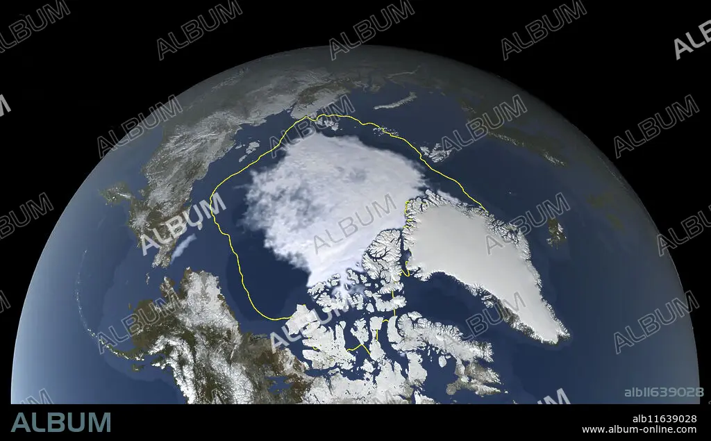
Traducción automática: Imagen satelital que muestra la capa de hielo polar del Ártico en su extensión mínima anual el 11 de septiembre de 2024. El hielo marino del Ártico (blanco, en el centro) alcanza un mínimo en septiembre, al final del verano ártico. Esta área mínima de hielo se denomina capa de hielo perenne. El hielo perenne ha estado disminuyendo de manera constante desde que los satélites comenzaron a observarlo en 1979, a un ritmo de aproximadamente el 10 por ciento por década. El límite amarillo muestra la extensión mínima promediada durante el período de 30 años de 1981 a 2010. El hielo marino de 2024 cubre 4,28 millones de kilómetros cuadrados y es la séptima extensión de hielo marino más baja desde que comenzaron los registros. La disminución de la capa de hielo perenne se atribuye al cambio climático. Datos del instrumento Radiómetro de Barrido de Microondas Avanzado 2 (AMSR2) de la Agencia de Exploración Aeroespacial de Japón a bordo de la Misión de Observación del Cambio Global 1st-Water (GCOM-W1)
Satellite image showing the Arctic polar ice cap at its annual minimum extent on 11th September 2024. The Arctic sea ice (white, centre) reaches a minimum in September, at the end of the Arctic summer. This minimal ice area is called the perennial ice cover. The perennial ice has been steadily decreasing since satellites began observing it in 1979, at a rate of about 10 percent per decade. The yellow boundary shows the minimum extent averaged over the 30-year period from 1981 to 2010. The 2024 sea ice covers 4.28 million square kilometres and is the 7th lowest sea ice extent since records began. The decrease in perennial ice cover is attributed to climate change. Data from the Japan Aerospace Exploration Agency's Advanced Microwave Scanning Radiometer 2 (AMSR2) instrument aboard the Global Change Observation Mission 1st-Water (GCOM-W1).
Crédito:
Album / NASA's Scientific Visualization Studio/SCIENCE PHOTO LIBRARY
Autorizaciones:
Modelo: No - Propiedad: No
¿Preguntas relacionadas con los derechos?
¿Preguntas relacionadas con los derechos?
Tamaño imagen:
3941 x 2240 px | 25.3 MB
Tamaño impresión:
33.4 x 19.0 cm | 13.1 x 7.5 in (300 dpi)
Palabras clave:
11 • 2 • 2024 • ADVANCED • AMBIENTAL • ANUALES • CALENTAMIENTO • DESAPARECIENDO • ESPACIAL • ESPACIALES • ESPACIO • EXPLORACION • FLOTA • GEOGRAFIA • GEOGRAFICO • HIELO • IMAGEN • MAR • MARINA • MARINE • MICROONDAS • MÍNIMO • MISION • MUNDIAL • NADIE • OCEANO • PERDER • PERDIDA • PLANETA TIERRA • REGION • RETROCESO • SATELITE • SEA • SEPTIEMBRE • SIGLO XXI • SIGLO
