alb10657479
Antonio Snider-Pellegrini's Globes, 1858, 2 of 2
| Compartir |
|---|
 Pinterest Pinterest |
 Twitter Twitter |
 Facebook Facebook |
 Copiar enlace Copiar enlace |
 Email Email |
|
Añadir a otro lightbox |
|
Añadir a otro lightbox |


¿Ya tienes cuenta? Iniciar sesión
¿No tienes cuenta? Regístrate
Compra esta imagen.
Selecciona el uso:

Título: Antonio Snider-Pellegrini's Globes, 1858, 2 of 2
Descripción: Ver traducción automática
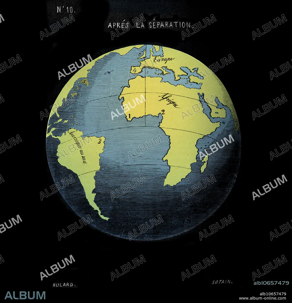
Snider-Pellegrini geological theory. Map of the continents before their separation, as depicted in 1858 by the French geographer Antonio Snider-Pellegrini. The map shows how the coastline of the Americas fits those of Europe and Africa. Snider-Pellegrini's theory was that the continents were created by God in this form, and were then separated by a volcanic explosion on the sixth day of creation. The idea that there was once a single supercontinent was not a new one, but the first modern theory of continental drift was that of Wegener, published in 1912. Map published in La Creation et ses Mysteres devoiles (Creation and its Mysteries Unveiled, 1858, Paris). This image has been colour enhanced.
Snider-Pellegrini geological theory. Map of the continents before their separation, as depicted in 1858 by the French geographer Antonio Snider-Pellegrini. The map shows how the coastline of the Americas fits those of Europe and Africa. Snider-Pellegrini's theory was that the continents were created by God in this form, and were then separated by a volcanic explosion on the sixth day of creation. The idea that there was once a single supercontinent was not a new one, but the first modern theory of continental drift was that of Wegener, published in 1912. Map published in La Creation et ses Mysteres devoiles (Creation and its Mysteries Unveiled, 1858, Paris). This image has been colour enhanced.
Personas: CONTINENTAL
Crédito: Album / Science Source
Autorizaciones: ? Cesión de modelo: No - ? Cesión de propiedad: No
¿Preguntas relacionadas con los derechos?
¿Preguntas relacionadas con los derechos?
Tamaño imagen: 5664 × 5595 px | 90.7 MB
Tamaño impresión: 48.0 × 47.4 cm | 2229.9 × 2202.8 in (300 dpi)
Palabras clave: 1800S • 1858 • AFRICA • AFRICANO • AMERICA • AMERICANO • ANTES • ANTONIO • ASIA • ASIATICO • AUSTRALIA • AUSTRALIANO • BIBLIA • BÍBLICO • CARTOGRAFIA • CARTOGRAFICO • CIENCIA • COLOR • COLOREADA • COLOREADO • COLORIDO • COMPARAR • CONTINENTAL • CONTINENTES • CONTRASTE • COSTA • DERIVA • DIAGRAMA • DIBUJO • EUROPA • EUROPEA • EUROPEAS • EUROPEO • EUROPEOS • FRANCES • GEOGRAFIA • GEOGRAFICA • GEOGRAFICO • GEOLOGIA • GEOLOGICO • GLOBO • GRABADO • HISTORIA • HISTORICO • IDEA • ILUSTRACION • ILUSTRACIONES • LITORAL • MAPA • MAYOR • MEJORA • MUNDIAL • MUNDO • NORTE • OBRA DE ARTE • PLACAS • PLANETA TIERRA • PLATO • S. XIX • SAGRADO • SECUENCIA • SIGLO XIX • SIGLO • SUR • TEORIA • TEORIAS • WEGENER
