alb9396355
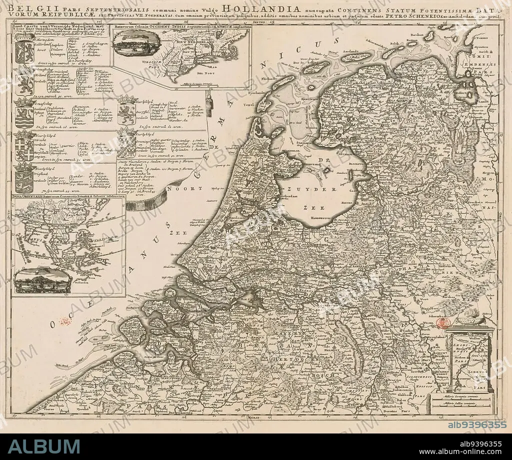
Map of the Republic of the Seven United Provinces, Land caerte van 't Verenigde Nederland met 't gene daer onderhoort verdeelt in syn provincien / Belgii pars septentrionalis communi nomine vulgo Hollandia (...) (title on object), Top left a cartouche with the arms of and topographical and political information about the Seven Provinces. To the right an inset map of New Netherland and an oval cityscape of New Amsterdam, accompanying scale bar: Milliaria Germanica communia. Below the former cartouche an inset map of the East Indies and an oval city view of Batavia. Bottom right an inset map of part of present-day Limburg (part that belonged to State Brabant at the time). Below that, scale bar: Milliaria Germanica communia, Milliaria Gallica communia. Degrees along edges., print maker: Pieter Schenk (I), (possibly), publisher: Pieter Schenk (I), (mentioned on object), Amsterdam, 1705, paper, engraving, etching, height 492 mm × width 593 mm.
| Compartir |
|---|
 Pinterest Pinterest |
 Twitter Twitter |
 Facebook Facebook |
 Copiar enlace Copiar enlace |
 Email Email |
|
Añadir a otro lightbox |
|
Añadir a otro lightbox |


¿Ya tienes cuenta? Iniciar sesión
¿No tienes cuenta? Regístrate
Compra esta imagen.
Selecciona el uso:

Descripción: Ver traducción automática
Map of the Republic of the Seven United Provinces, Land caerte van 't Verenigde Nederland met 't gene daer onderhoort verdeelt in syn provincien / Belgii pars septentrionalis communi nomine vulgo Hollandia (...) (title on object), Top left a cartouche with the arms of and topographical and political information about the Seven Provinces. To the right an inset map of New Netherland and an oval cityscape of New Amsterdam, accompanying scale bar: Milliaria Germanica communia. Below the former cartouche an inset map of the East Indies and an oval city view of Batavia. Bottom right an inset map of part of present-day Limburg (part that belonged to State Brabant at the time). Below that, scale bar: Milliaria Germanica communia, Milliaria Gallica communia. Degrees along edges., print maker: Pieter Schenk (I), (possibly), publisher: Pieter Schenk (I), (mentioned on object), Amsterdam, 1705, paper, engraving, etching, height 492 mm × width 593 mm
Map of the Republic of the Seven United Provinces, Land caerte van 't Verenigde Nederland met 't gene daer onderhoort verdeelt in syn provincien / Belgii pars septentrionalis communi nomine vulgo Hollandia (...) (title on object), Top left a cartouche with the arms of and topographical and political information about the Seven Provinces. To the right an inset map of New Netherland and an oval cityscape of New Amsterdam, accompanying scale bar: Milliaria Germanica communia. Below the former cartouche an inset map of the East Indies and an oval city view of Batavia. Bottom right an inset map of part of present-day Limburg (part that belonged to State Brabant at the time). Below that, scale bar: Milliaria Germanica communia, Milliaria Gallica communia. Degrees along edges., print maker: Pieter Schenk (I), (possibly), publisher: Pieter Schenk (I), (mentioned on object), Amsterdam, 1705, paper, engraving, etching, height 492 mm × width 593 mm
Personas: PIETER SCHENK
Crédito: Album / quintlox
Autorizaciones: ? Cesión de modelo: No - ? Cesión de propiedad: No
¿Preguntas relacionadas con los derechos?
¿Preguntas relacionadas con los derechos?
Tamaño imagen: 5099 × 4316 px | 63.0 MB
Tamaño impresión: 43.2 × 36.5 cm | 2007.5 × 1699.2 in (300 dpi)
