alb5406853
Halifax Explosion, Map,1917
| Compartir |
|---|
 Pinterest Pinterest |
 Twitter Twitter |
 Facebook Facebook |
 Copiar enlace Copiar enlace |
 Email Email |
|
Añadir a otro lightbox |
|
Añadir a otro lightbox |


¿Ya tienes cuenta? Iniciar sesión
¿No tienes cuenta? Regístrate
Compra esta imagen.
Selecciona el uso:

Título: Halifax Explosion, Map,1917
Descripción: Ver traducción automática
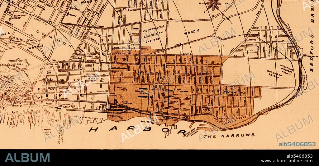
The Halifax Explosion occurred in Halifax, Nova Scotia, Canada, on December 6th, 1917, when the Mont-Blanc, a French cargo ship carrying high explosives, collided with another ship in the Narrows near Halifax Harbour. A fire on board the Mont-Blanc caused a massive explosion that destroyed a large section of Halifax (see darker area), killing 2,000 people and injuring 9,000.
The Halifax Explosion occurred in Halifax, Nova Scotia, Canada, on December 6th, 1917, when the Mont-Blanc, a French cargo ship carrying high explosives, collided with another ship in the Narrows near Halifax Harbour. A fire on board the Mont-Blanc caused a massive explosion that destroyed a large section of Halifax (see darker area), killing 2,000 people and injuring 9,000.
Crédito: Album / Science Source
Autorizaciones: ? Cesión de modelo: No - ? Cesión de propiedad: No
¿Preguntas relacionadas con los derechos?
¿Preguntas relacionadas con los derechos?
Tamaño imagen: 3900 × 1834 px | 20.5 MB
Tamaño impresión: 33.0 × 15.5 cm | 1535.4 × 722.0 in (300 dpi)
Palabras clave: 1917 • ARTICULO DE PERIODICO • CANADA • DESASTRE • EXPLOTAR • HISTORIA • ILUSTRACION • ILUSTRACIONES • MAPA • PUERTO • RICHMOND • S. XX • SIGLO XX • TITULAR
