alb3823093
Map of Spanish America, 16th Century
| Compartir |
|---|
 Pinterest Pinterest |
 Twitter Twitter |
 Facebook Facebook |
 Copiar enlace Copiar enlace |
 Email Email |
|
Añadir a otro lightbox |
|
Añadir a otro lightbox |


¿Ya tienes cuenta? Iniciar sesión
¿No tienes cuenta? Regístrate
Compra esta imagen.
Selecciona el uso:

Título: Map of Spanish America, 16th Century
Descripción:
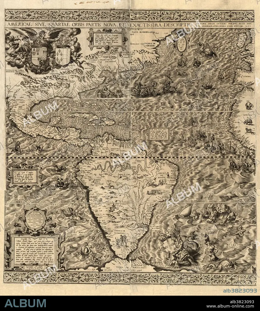
Traducción automática: América española. Mapa de América elaborado por el cartógrafo español Diego Gutiérrez en 1562. Sólo se sabe que existen dos copias de este mapa, una en la Biblioteca del Congreso de Estados Unidos y otra en la Biblioteca Británica. Numerosas ilustraciones muestran animales terrestres y marinos, barcos, nativos sudamericanos, un volcán mexicano, ríos sudamericanos (Amazonas y Paraná) y cadenas montañosas. El mapa muestra los dominios españoles después de un tratado de 1559 entre España y Francia (sus escudos de armas están en la parte superior izquierda, España a la izquierda; el de Portugal está en la parte inferior derecha). Junto al escudo de armas de Francia hay una nota que dice que Americus Vespucius descubrió América en 1497. El mapa fue grabado por el artista flamenco Hieronymous Cock.
Spanish America. Map of America produced by the Spanish cartographer Diego Gutierrez in 1562. Only two copies of this map are known to exist, one in the US Library of Congress, and one in the British Library. Numerous illustrations show land and sea animals, ships, South American natives, a Mexican volcano, South American rivers (Amazon and Parana) and mountain ranges. The map shows Spanish domains following a 1559 treaty between Spain and France (their coats of arms are both at top left, Spain at left; Portugal's is at lower right). Next to France's coat of arms is a note that says Americus Vespucius discovered America in 1497. The map was engraved by the Flemish artist Hieronymous Cock.
Crédito: Album / Science Source / LOC/Geography and Map Division
Autorizaciones: ? Cesión de modelo: No - ? Cesión de propiedad: No
¿Preguntas relacionadas con los derechos?
¿Preguntas relacionadas con los derechos?
Tamaño imagen: 4300 × 4880 px | 60.0 MB
Tamaño impresión: 36.4 × 41.3 cm | 1692.9 × 1921.3 in (300 dpi)
Palabras clave: 1562 • AMÉRICA DEL NORTE • AMERICA SEPTENTRIONAL • AMERICA • AMERICANO • AMERICAS • AMERICAS, LAS • ANIMAL • ANIMALES • ANTIGUO • BARCOS • CARTOGRAFIA • CONTINENTE AMERICANO • CONTINENTE • CONTINENTES • DIAGRAMA • ESCUDO DE ARMAS • ESPANA • ESPANOL • ESPAÑA • FRANCES • FRANCIA • GEOGRAFIA • GEOGRAFICO • HEMISFERIO OCCIDENTAL • HISTORIA • HISTORICO • ILUSTRACION • ILUSTRACIONES • ILUSTRADO • INCOMPLETO • INEXACTA • MAPA • MAR • NATIVOS • NORTEAMERICA • OBRA DE ARTE • PARANÀ • PORTRAIT • PORTUGAL • PORTUGUES • RARAS • RENACIMIENTO • RETRATO • RIO • RIOS • S. XVI • SIGLO XVI • SUDAMERICA • TIERRA (TERRENO) • VERTICAL • VOLCAN
