alb5392360
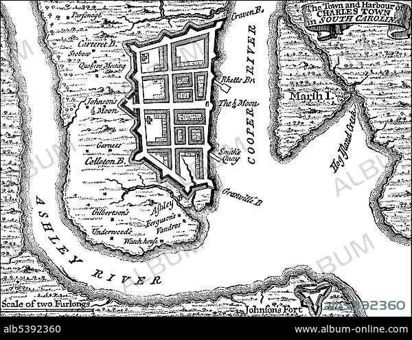
Historical drawing, US-American history, 18th century, map of Charlestown, Boston, Massachusetts, USA, 1780, North America.
| Compartir |
|---|
 Pinterest Pinterest |
 Twitter Twitter |
 Facebook Facebook |
 Copiar enlace Copiar enlace |
 Email Email |
|
Añadir a otro lightbox |
|
Añadir a otro lightbox |


¿Ya tienes cuenta? Iniciar sesión
¿No tienes cuenta? Regístrate
Compra esta imagen.
Selecciona el uso:

Descripción:
Ver traducción automática
Historical drawing, US-American history, 18th century, map of Charlestown, Boston, Massachusetts, USA, 1780, North America
Crédito:
Album / ImageBroker / H.-D. Falkenstein
Autorizaciones:
Tamaño imagen:
4762 x 3670 px | 50.0 MB
Tamaño impresión:
40.3 x 31.1 cm | 15.9 x 12.2 in (300 dpi)
Palabras clave:
AMÉRICA DEL NORTE • AMERICA SEPTENTRIONAL • BLANCO Y NEGRO • BOCETO • BOSTON • CARTAS • CIUDAD • CIUDADES • DIBUJO • DIBUJOS • EDAD • EE. UU • EE. UU. • EEUU / ESTADOS UNIDOS • EEUU • ESTADOS UNIDOS DE AMERICA • ESTADOS UNIDOS • HISTORIA • HISTORICO • LETRAS • MAPA URBANO • MAPA • MASSACHUSETTS • NORTEAMERICA • PLANES • PLANIFICACIÓN • REPRESENTACIONES • S. XVIII • SIGLO XVIII • TARJETA • TARJETAS • U. S. A. • URBANO • USA • VISIÓN GENERAL • VISTAS GENERALES
