alb3820347
Macrobius T and O Medieval World Map
| Compartir |
|---|
 Pinterest Pinterest |
 Twitter Twitter |
 Facebook Facebook |
 Copiar enlace Copiar enlace |
 Email Email |
|
Añadir a otro lightbox |
|
Añadir a otro lightbox |


¿Ya tienes cuenta? Iniciar sesión
¿No tienes cuenta? Regístrate
Compra esta imagen.
Selecciona el uso:

Título:
Macrobius T and O Medieval World Map
Descripción:
Ver traducción automática
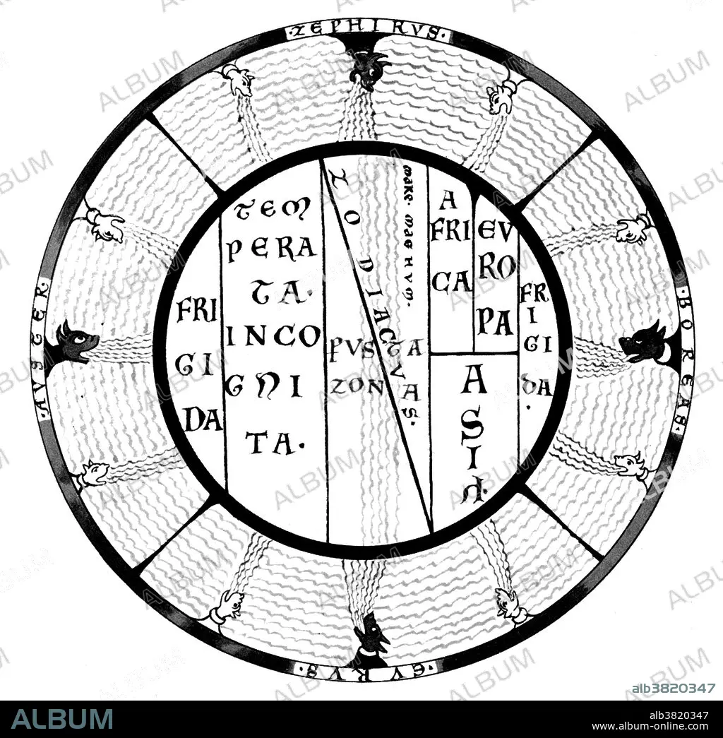
Macrobius T and O map of the Medieval world with the climatic zones and the Mare Magnum, the Great Ocean which was thought to separate the inhabited seanworld from an unknown continent in the south. Macrobius Ambrosius Theodosius was a Roman who flourished during the early fifth century. His Commentarii in Somnium Scipionis (Commentary on the Dream of Scipio) allowed him to discourse upon the nature of the cosmos, transmitting much classical philosophy to the later Middle Ages. The T and O map is representing only the top-half of the spherical Earth. It was a projection of the inhabited parts, the northern temperate half of the globe. Since the southern temperate clime was considered uninhabited, there was no need to depict them on a world map. It was then believed that no one could cross the torrid equatorial clime and reach the unknown lands on the other half of the globe. These imagined lands were called antipodes. The T is the Mediterranean, the Nile, and the Don (formerly called the Tanais) dividing the three continents, Asia, Europe and Africa, and the O is the encircling ocean. Jerusalem was generally represented in the center of the map. Asia was typically the size of the other two continents combined. Because the sun rose in the east, Paradise (the Garden of Eden) was generally depicted as being in Asia, and Asia was situated at the top portion of the map.
Crédito:
Album / Science Source / New York Public Library
Autorizaciones:
Tamaño imagen:
4200 x 4068 px | 48.9 MB
Tamaño impresión:
35.6 x 34.4 cm | 14.0 x 13.6 in (300 dpi)
Palabras clave:
ASTRONOMIA • ASTRONÓMICO • BLANCO Y NEGRO • CARTOGRAFIA • CELESTE • CELESTIAL SPHERE • CELESTIAL • CIENCIA • EDAD MEDIA • ESFERA CELESTE • FAMOSA • FAMOSO • FAMOSOS • HISTORIA • HISTORICO • IMPORTANTE • MAPA • MEDIEVAL
