alb4068058
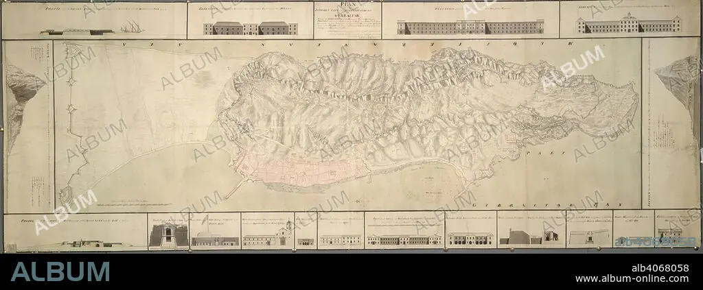
A plan of the isthmus, city and fortifications of Gibraltar. A colored "plan of the isthmus, city, and fortifications of Gibraltar, shewing elevations and sections of the principal public buildings, profiles through the two extremities of the rock, and forts built by the Spaniards; also the soundings and particular heights of the hill laid down on the plan, with several additional designs for better defending and securing the place;". 1751. Source: Maps K.Top.72.36. Language: English.
| Compartir |
|---|
 Pinterest Pinterest |
 Twitter Twitter |
 Facebook Facebook |
 Copiar enlace Copiar enlace |
 Email Email |
|
Añadir a otro lightbox |
|
Añadir a otro lightbox |


¿Ya tienes cuenta? Iniciar sesión
¿No tienes cuenta? Regístrate
Compra esta imagen

Descripción:
Ver traducción automática
A plan of the isthmus, city and fortifications of Gibraltar. A colored "plan of the isthmus, city, and fortifications of Gibraltar, shewing elevations and sections of the principal public buildings, profiles through the two extremities of the rock, and forts built by the Spaniards; also the soundings and particular heights of the hill laid down on the plan, with several additional designs for better defending and securing the place;". 1751. Source: Maps K.Top.72.36. Language: English.
Personas:
Crédito:
Album / British Library
Autorizaciones:
Modelo: No - Propiedad: No
¿Preguntas relacionadas con los derechos?
¿Preguntas relacionadas con los derechos?
Tamaño imagen:
10500 x 3798 px | 114.1 MB
Tamaño impresión:
88.9 x 32.2 cm | 35.0 x 12.7 in (300 dpi)
Palabras clave:
