alb4475187
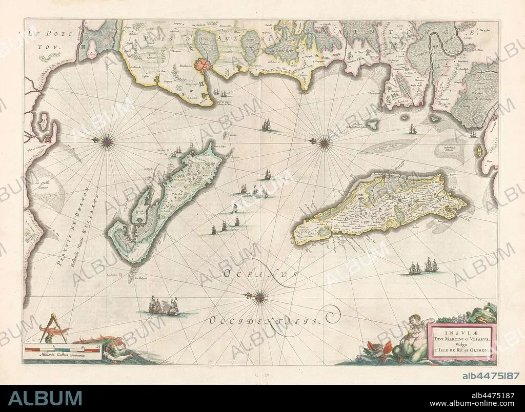
Cartography in the Netherlands, map of the French coast near La Rochelle and the islands of Ré and Oleron, Map of the islands of Ré and Oleron and the French coast, borders and coasts colored. Three compass roses, r.b, m.o. and l.b. The north is on the left. Ships in the sea. L.o. scale in French miles with sea monster and compass. R.o. with inscription allegorical figures. VErso: 2 pages of text, 2 columns each. Inscription, ro: INSLAVAE / DIVI MARTINI and VLIARVS, Vulgo / L'ISLE DE RE and OLERON., Mercator, 1600 - 1650, paper, engraving, h 39 cm × w 53.7 cm.
| Compartir |
|---|
 Pinterest Pinterest |
 Twitter Twitter |
 Facebook Facebook |
 Copiar enlace Copiar enlace |
 Email Email |
|
Añadir a otro lightbox |
|
Añadir a otro lightbox |


¿Ya tienes cuenta? Iniciar sesión
¿No tienes cuenta? Regístrate
Compra esta imagen

Descripción:
Ver traducción automática
Cartography in the Netherlands, map of the French coast near La Rochelle and the islands of Ré and Oleron, Map of the islands of Ré and Oleron and the French coast, borders and coasts colored. Three compass roses, r.b, m.o. and l.b. The north is on the left. Ships in the sea. L.o. scale in French miles with sea monster and compass. R.o. with inscription allegorical figures. VErso: 2 pages of text, 2 columns each. Inscription, ro: INSLAVAE / DIVI MARTINI and VLIARVS, Vulgo / L'ISLE DE RE and OLERON., Mercator, 1600 - 1650, paper, engraving, h 39 cm × w 53.7 cm
Crédito:
Album / quintlox
Autorizaciones:
Modelo: No - Propiedad: No
¿Preguntas relacionadas con los derechos?
¿Preguntas relacionadas con los derechos?
Tamaño imagen:
5564 x 4083 px | 65.0 MB
Tamaño impresión:
47.1 x 34.6 cm | 18.5 x 13.6 in (300 dpi)
Palabras clave:
1650 • AGUAFUERTE • BARCO • CARTOGRAFIA • ENGRAVING • ESCALA • FLOTA • FRONTERAS • GRABADO • GRABADOS • INSCRIPCION • ISLA • IZQUIERDA • LA ROCHELLE • MAPA • MAR • MARINA • MARINE • MONSTRUO MARINO • NORTE • OCEANO • OLÉRON • PAISES BAJOS • PAPEL • SEA • TEXTO • VERSO
