alb1963704
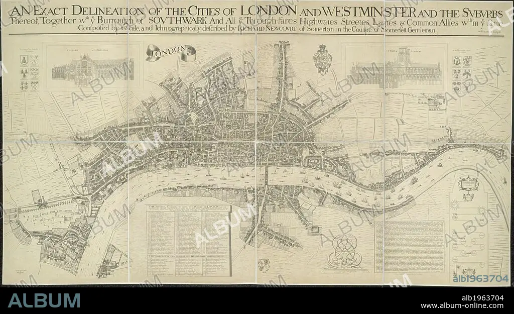
RICHARD NEWCOURT. A map of the Cities of London and Westminster. It depicts London as it stood during the last two years of the Commonwealth, before the Great Fire. Dense clusters of houses appear very close together, separated only by narrow streets - an indication of the city's vulnerability to fire. An exact delineation of the Cities of London and Westminster and the suburbs thereof, together wth. ye Burrough of Southwark. 1857. This is a copy of the 1658 Faithorne map made in 1857. . Source: Maps.Crace.I.35.
| Compartir |
|---|
 Pinterest Pinterest |
 Twitter Twitter |
 Facebook Facebook |
 Copiar enlace Copiar enlace |
 Email Email |
|
Añadir a otro lightbox |
|
Añadir a otro lightbox |


¿Ya tienes cuenta? Iniciar sesión
¿No tienes cuenta? Regístrate
Compra esta imagen.
Selecciona el uso:

Autor:
Descripción:
Ver traducción automática
A map of the Cities of London and Westminster. It depicts London as it stood during the last two years of the Commonwealth, before the Great Fire. Dense clusters of houses appear very close together, separated only by narrow streets - an indication of the city's vulnerability to fire. An exact delineation of the Cities of London and Westminster and the suburbs thereof, together wth. ye Burrough of Southwark. 1857. This is a copy of the 1658 Faithorne map made in 1857. . Source: Maps.Crace.I.35.
Crédito:
Album / British Library
Autorizaciones:
Modelo: No - Propiedad: No
¿Preguntas relacionadas con los derechos?
¿Preguntas relacionadas con los derechos?
Tamaño imagen:
10000 x 5589 px | 159.9 MB
Tamaño impresión:
84.7 x 47.3 cm | 33.3 x 18.6 in (300 dpi)
Palabras clave:
ACONTECIMIENTO • ALBION • ANIVERSARIO • ANIVERSARIOS • CARTOGRAFIA • CARTOGRAFICO • CATASTROFE • DESASTRE • DESASTRES • ESTILO Y PERIODO • EUROPA OCCIDENTAL • EUROPA • GRAN BRETAÑA • INGLATERRA • ISLAS BRITANICAS • LONDON • LONDRES • MAPA • NEWCOURT, RICHARD • RIO TAMESIS • RIO • S. XIX • SIGLO XIX • SIGLO XVII • TAMESIS • WESTMINSTER
