alb4056304
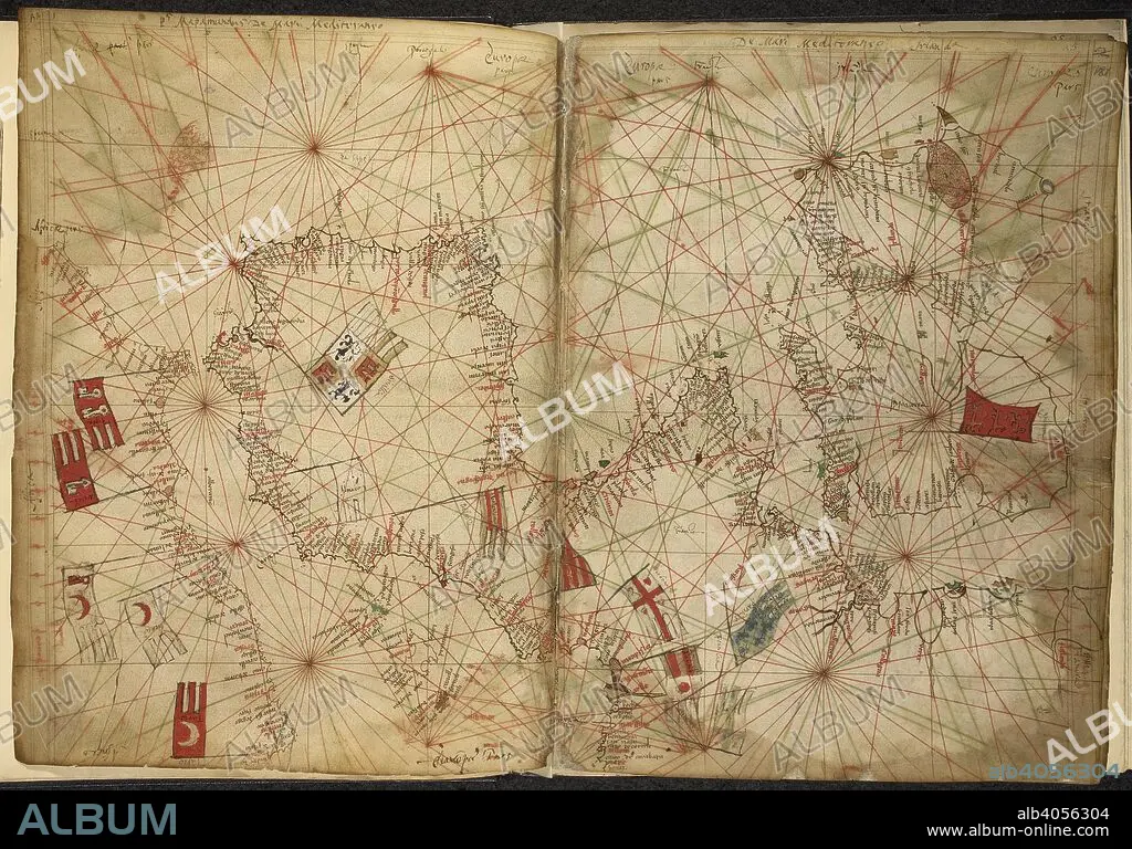
PIETRO VESCONTE. Portolan chart of western Europe and the Mediterranean, with the principal powers indicated by means of flags. Maps for the Liber Secretorum Fidelium Crucis. Italy (Venice); circa 1320-1325. (Whole folios) Portolan chart of western Europe and the Mediterranean, with the principal powers indicated by means of flags. Image taken from Maps for the Liber Secretorum Fidelium Crucis. Originally published/produced in Italy (Venice); circa 1320-1325. . Source: Add. 27376*, ff.180v-181. Language: Latin.
| Compartir |
|---|
 Pinterest Pinterest |
 Twitter Twitter |
 Facebook Facebook |
 Copiar enlace Copiar enlace |
 Email Email |
|
Añadir a otro lightbox |
|
Añadir a otro lightbox |


¿Ya tienes cuenta? Iniciar sesión
¿No tienes cuenta? Regístrate
Compra esta imagen.
Selecciona el uso:

Autor: PIETRO VESCONTE
Descripción:
Traducción automática: Carta portulana de Europa occidental y el Mediterráneo, con las principales potencias indicadas mediante banderas. Mapas del Liber Secretorum Fidelium Crucis. Italia (Venecia); hacia 1320-1325. (Folios enteros) Carta portulana de Europa occidental y el Mediterráneo, con las principales potencias indicadas mediante banderas. Imagen tomada de Mapas del Liber Secretorum Fidelium Crucis. Publicado/producido originalmente en Italia (Venecia); hacia 1320-1325. . Fuente: Añadir. 27376*, ff.180v-181. Idioma: latín
Portolan chart of western Europe and the Mediterranean, with the principal powers indicated by means of flags. Maps for the Liber Secretorum Fidelium Crucis. Italy (Venice); circa 1320-1325. (Whole folios) Portolan chart of western Europe and the Mediterranean, with the principal powers indicated by means of flags. Image taken from Maps for the Liber Secretorum Fidelium Crucis. Originally published/produced in Italy (Venice); circa 1320-1325. . Source: Add. 27376*, ff.180v-181. Language: Latin.
Crédito: Album / British Library
Autorizaciones: ? Cesión de modelo: No - ? Cesión de propiedad: No
¿Preguntas relacionadas con los derechos?
¿Preguntas relacionadas con los derechos?
Tamaño imagen: 6872 × 4798 px | 94.3 MB
Tamaño impresión: 58.2 × 40.6 cm | 2705.5 × 1889.0 in (300 dpi)
Palabras clave: CARTOGRAFIA • CARTOGRAFICO • COLOR • COLORES • COLORIDO • DOCUMENTO • EUROPA OCCIDENTAL • EUROPA • GRAFICO • MANUSCRITO • MAPA • MAPAS • MAR MEDITERRANEO • MEDITERRANEO • PIETRO VESCONTE • S. XIV • SIGLO XIV
