alb5407050
Joan Blaeu, Rhine River Map,17th Century
| Compartir |
|---|
 Pinterest Pinterest |
 Twitter Twitter |
 Facebook Facebook |
 Copiar enlace Copiar enlace |
 Email Email |
|
Añadir a otro lightbox |
|
Añadir a otro lightbox |


¿Ya tienes cuenta? Iniciar sesión
¿No tienes cuenta? Regístrate
Compra esta imagen.
Selecciona el uso:

Título: Joan Blaeu, Rhine River Map,17th Century
Descripción: Ver traducción automática
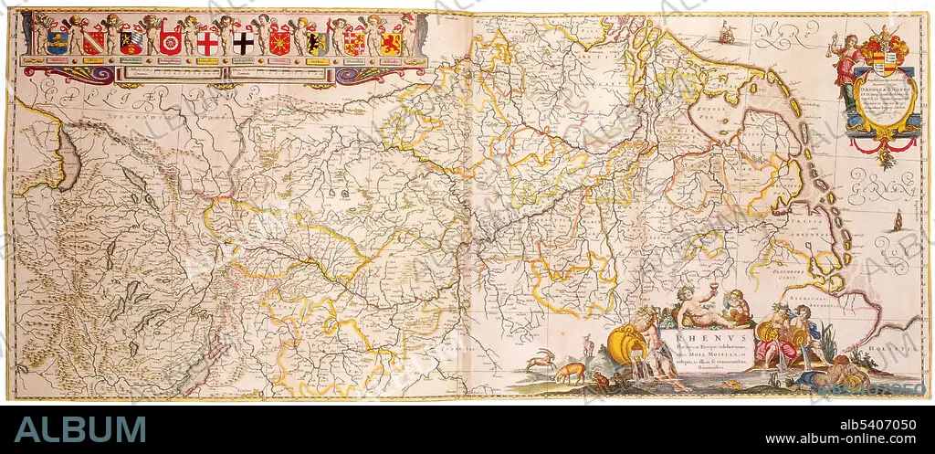
The Rhine and the Danube formed most of the northern inland frontier of the Roman Empire and, since those days, the Rhine has been a vital and navigable waterway carrying trade and goods deep inland. Its importance as a waterway in the Holy Roman Empire is supported by the many castles and fortifications built along it. It is the second-longest river in Central and Western Europe (after the Danube), at about 760 miles. Joan Blaeu (1596-1673) was a Dutch cartographer, the son of cartographer Willem Blaeu. In 1635 they published the Atlas Novus (full title: Theatrum orbis terrarum, sive, Atlas novus) in two volumes. The Atlas Maior is the final version of Joan Blaeu's atlas, published in Amsterdam between 1662 and 1672, in Latin, French, Dutch, German and Spanish, containing 594 maps and around 3,000 pages of text.
The Rhine and the Danube formed most of the northern inland frontier of the Roman Empire and, since those days, the Rhine has been a vital and navigable waterway carrying trade and goods deep inland. Its importance as a waterway in the Holy Roman Empire is supported by the many castles and fortifications built along it. It is the second-longest river in Central and Western Europe (after the Danube), at about 760 miles. Joan Blaeu (1596-1673) was a Dutch cartographer, the son of cartographer Willem Blaeu. In 1635 they published the Atlas Novus (full title: Theatrum orbis terrarum, sive, Atlas novus) in two volumes. The Atlas Maior is the final version of Joan Blaeu's atlas, published in Amsterdam between 1662 and 1672, in Latin, French, Dutch, German and Spanish, containing 594 maps and around 3,000 pages of text.
Crédito: Album / Science Source
Autorizaciones: ? Cesión de modelo: No - ? Cesión de propiedad: No
¿Preguntas relacionadas con los derechos?
¿Preguntas relacionadas con los derechos?
Tamaño imagen: 5700 × 2470 px | 40.3 MB
Tamaño impresión: 48.3 × 20.9 cm | 2244.1 × 972.4 in (300 dpi)
Palabras clave: ATLAS • CARTOGRAFIA • CARTOGRAFICO • DORADO • EDAD • FAMOSA • FAMOSO • FAMOSOS • GEOGRAFIA • GEOGRAFICA • GEOGRAFICO • HISTORIA • HISTORICO • HOLANDES • IMPORTANTE • JOAN • MAPA • RIO • SIGLO XVII • SIGLO
