alb4061169
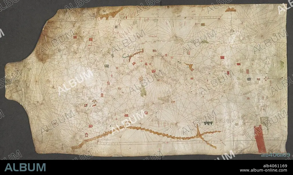
ANGELINO DULCERT. Chart of the Mediterranean Sea, from the Canary Islands to the Red Sea. A church marks the city of Rome in the centre. Italy; late 14th century. Source: Add. 25691. Language: Latin and Italian.
| Compartir |
|---|
 Pinterest Pinterest |
 Twitter Twitter |
 Facebook Facebook |
 Copiar enlace Copiar enlace |
 Email Email |
|
Añadir a otro lightbox |
|
Añadir a otro lightbox |


¿Ya tienes cuenta? Iniciar sesión
¿No tienes cuenta? Regístrate
Compra esta imagen.
Selecciona el uso:

Autor: ANGELINO DULCERT
Descripción: Ver traducción automática
Chart of the Mediterranean Sea, from the Canary Islands to the Red Sea. A church marks the city of Rome in the centre. Italy; late 14th century. Source: Add. 25691. Language: Latin and Italian.
Chart of the Mediterranean Sea, from the Canary Islands to the Red Sea. A church marks the city of Rome in the centre. Italy; late 14th century. Source: Add. 25691. Language: Latin and Italian.
Crédito: Album / British Library
Autorizaciones: ? Cesión de modelo: No - ? Cesión de propiedad: No
¿Preguntas relacionadas con los derechos?
¿Preguntas relacionadas con los derechos?
Tamaño imagen: 8911 × 4853 px | 123.7 MB
Tamaño impresión: 75.4 × 41.1 cm | 3508.3 × 1910.6 in (300 dpi)
Palabras clave: AFRICA • ASENTAMIENTO • ASENTAMIENTOS • ATLANTICO • CANARIA • CANARIAS • CARTOGRAFIA • CHURCH • CIUDAD • COLOR ROJO • COLOR • COLORIDO • DULCERT, ANGELINO • EDIFICIO RELIGIOSO • EN ROJO • ESTRUCTURA RELIGIOSA • EUROPA • FLOTA • GRAFICO • IGLESIA • ISLAS CANARIAS • MAR • MARINA • MARINE • OCEANO ATLANTICO • OCEANO • ROJA • ROJO (COLOR) • ROJO • SEA • SUR DE EUROPA • TOPOGRAFIA
