alb5410307
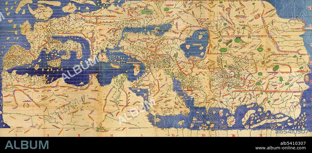
Tabula Rogeriana, Upside-Down with North Up, Al-Idrisi,1154
| Compartir |
|---|
 Pinterest Pinterest |
 Twitter Twitter |
 Facebook Facebook |
 Copiar enlace Copiar enlace |
 Email Email |
|
Añadir a otro lightbox |
|
Añadir a otro lightbox |


¿Ya tienes cuenta? Iniciar sesión
¿No tienes cuenta? Regístrate
Compra esta imagen.
Selecciona el uso:

Título:
Tabula Rogeriana, Upside-Down with North Up, Al-Idrisi,1154
Descripción:
Traducción automática: La Tabula Rogeriana, dibujada por Al-Idrisi para Roger II de Sicilia en 1154, fue uno de los mapas del mundo más avanzados de su época y mostraba Europa, Asia y parte de África. Aquí está orientado al revés con el norte hacia arriba. Muhammad al-Idrisi fue un geógrafo, cartógrafo y egiptólogo árabe musulmán que vivió en Palermo, Sicilia, en la corte del rey Roger II.
The Tabula Rogeriana, drawn by Al-Idrisi for Roger II of Sicily in 1154, was one of the most advanced world maps of its era, showing Europe, Asia, and part of Africa. Here is it oriented upside-down with north up. Muhammad al-Idrisi was an Arab Muslim geographer, cartographer and Egyptologist who lived in Palermo, Sicily at the court of King Roger II.
Crédito:
Album / Science Source
Autorizaciones:
Modelo: No - Propiedad: No
¿Preguntas relacionadas con los derechos?
¿Preguntas relacionadas con los derechos?
Tamaño imagen:
8100 x 3567 px | 82.7 MB
Tamaño impresión:
68.6 x 30.2 cm | 27.0 x 11.9 in (300 dpi)
