alb3825399
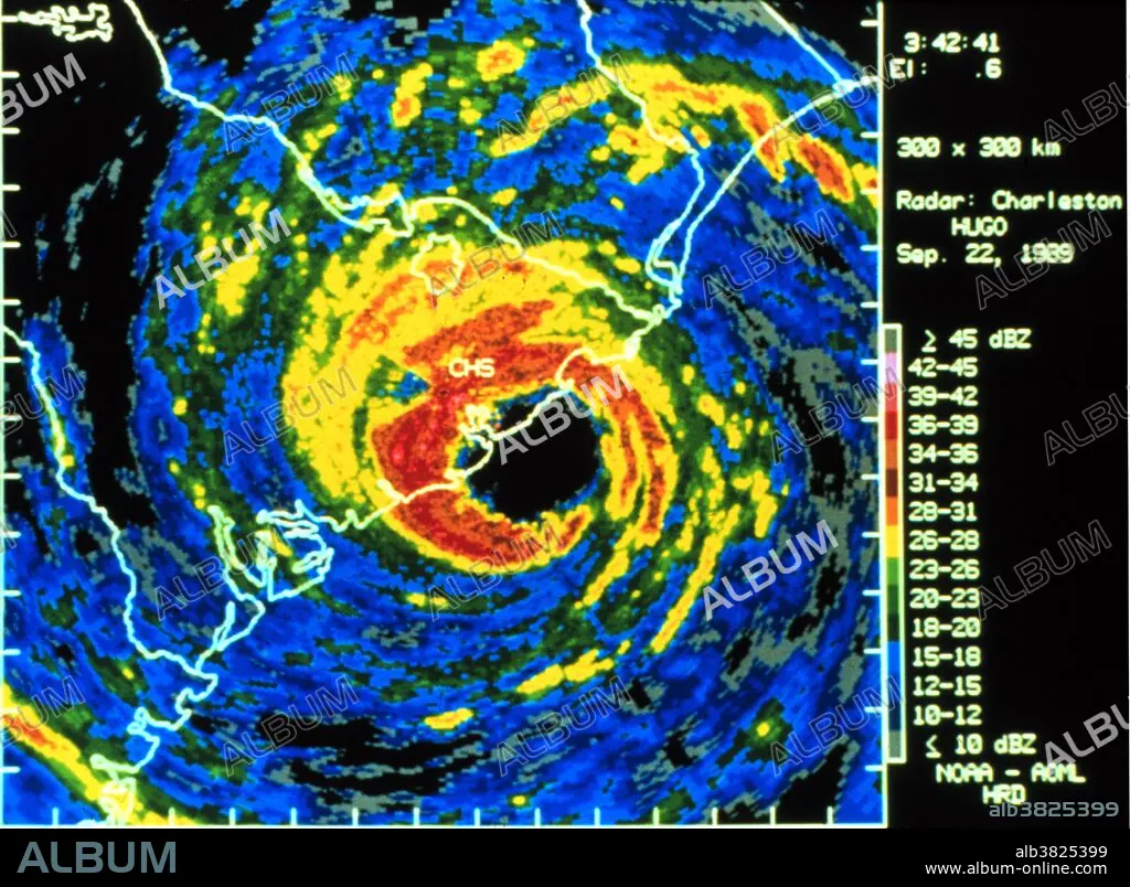
Hurricane Hugo, Digitized Radar Image, 1989
| Compartir |
|---|
 Pinterest Pinterest |
 Twitter Twitter |
 Facebook Facebook |
 Copiar enlace Copiar enlace |
 Email Email |
|
Añadir a otro lightbox |
|
Añadir a otro lightbox |


¿Ya tienes cuenta? Iniciar sesión
¿No tienes cuenta? Regístrate
Compra esta imagen.
Selecciona el uso:

Título:
Hurricane Hugo, Digitized Radar Image, 1989
Descripción:
Ver traducción automática
Digitized Charleston WSR-57 radar image of Hugo with superimposed winds. Real-time winds measured onboard NOAA research aircraft flying into Hugo. Wind velocity transmitted to NHC through a satellite link as eyewall hit coast. Sustained winds of 155 mph at 10,000 feet and 135 mph at surface. Higher gusts were estimated in area of landfall. 1989. Hurricane Hugo was a classical, destructive and rare Cape Verde-type hurricane which struck the Caribbean islands of Guadeloupe, Montserrat, St. Croix, Puerto Rico and the USA mainland in South Carolina as a Category 4 hurricane during September of the 1989 Atlantic hurricane season. Hurricane Hugo caused 34 fatalities (most by electrocution or drowning) in the Caribbean and 27 in South Carolina, left nearly 100,000 homeless, and resulted in $9 billion (1999 USD, $15.9 billion 2011 USD) in damage overall, making it the most damaging hurricane ever recorded at that particular time (surpassed by Andrew 3 years later).
Crédito:
Album / NOAA/Science Source
Autorizaciones:
Tamaño imagen:
3750 x 2750 px | 29.5 MB
Tamaño impresión:
31.8 x 23.3 cm | 12.5 x 9.2 in (300 dpi)
Palabras clave:
ACERCARSE • AMERICA • AMERICANO • ATMOSFERICO • CIENCIA • CLIMA • ESTADOS UNIDOS DE AMERICA • ESTADOS UNIDOS • FENÓMENO NATURAL • FENOMENOS NATURALES • HISTORIA • HISTORICO • HURACAN • METEOROLOGÍA • METEOROLÓGICO • METEREOLOGIA • METEREOLÓGICOS • MORTAL • RARAS • S. XX • SEPTIEMBRE • SIGLO XX • TORMENTA • VIOLENTOS
