alb3841089
Richat Structure, Sahara, Landsat / SRTM Image
| Compartir |
|---|
 Pinterest Pinterest |
 Twitter Twitter |
 Facebook Facebook |
 Copiar enlace Copiar enlace |
 Email Email |
|
Añadir a otro lightbox |
|
Añadir a otro lightbox |


¿Ya tienes cuenta? Iniciar sesión
¿No tienes cuenta? Regístrate
Compra esta imagen.
Selecciona el uso:

Título: Richat Structure, Sahara, Landsat / SRTM Image
Descripción: Ver traducción automática
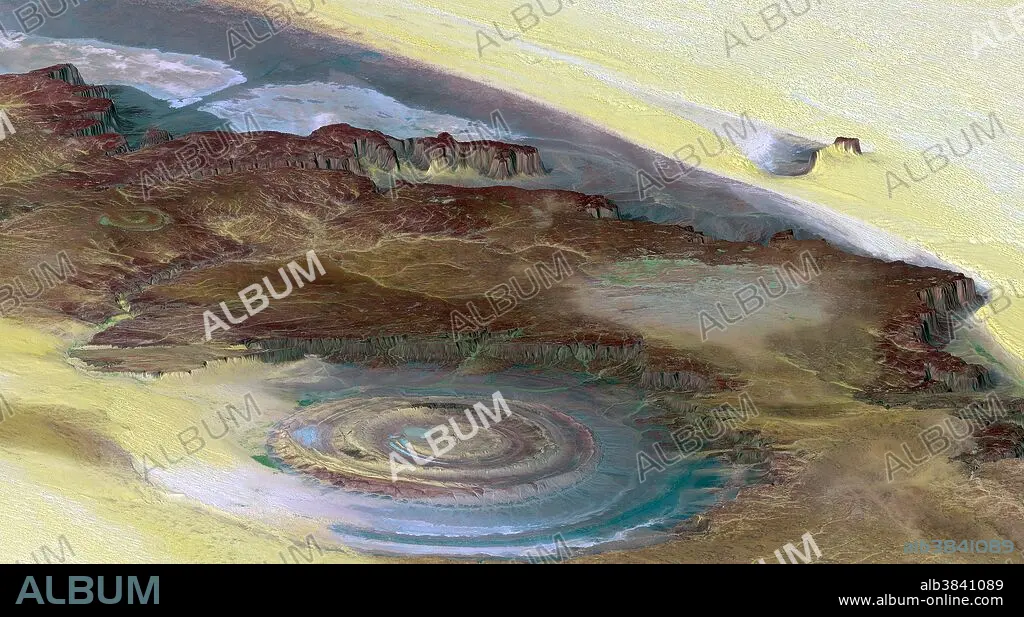
This prominent circular feature, known as the Richat Structure, in the Sahara desert of Mauritania is often noted by astronauts because it forms a conspicuous 30-mile-wide bull's-eye on the otherwise rather featureless expanse of the desert. Initially mistaken for a possible impact crater, it is now known to be an eroded circular anticline (structural dome) of layered sedimentary rocks. This view was generated from a Landsat satellite image draped over an elevation model produced by the Shuttle Radar Topography Mission. The view uses a 6-times vertical exaggeration to greatly enhance topographic expression. Colors of the scene were enhanced by use of a combination of visible and infrared bands, which helps to differentiate bedrock (browns), sand (yellow, some white), minor vegetation in drainage channels (green), and salty sediments (bluish whites). Some shading of the elevation model was included to further highlight the topographic features. Elevation data was acquired by the SRTM aboard the Space Shuttle Endeavour, launched on February 11, 2000.
This prominent circular feature, known as the Richat Structure, in the Sahara desert of Mauritania is often noted by astronauts because it forms a conspicuous 30-mile-wide bull's-eye on the otherwise rather featureless expanse of the desert. Initially mistaken for a possible impact crater, it is now known to be an eroded circular anticline (structural dome) of layered sedimentary rocks. This view was generated from a Landsat satellite image draped over an elevation model produced by the Shuttle Radar Topography Mission. The view uses a 6-times vertical exaggeration to greatly enhance topographic expression. Colors of the scene were enhanced by use of a combination of visible and infrared bands, which helps to differentiate bedrock (browns), sand (yellow, some white), minor vegetation in drainage channels (green), and salty sediments (bluish whites). Some shading of the elevation model was included to further highlight the topographic features. Elevation data was acquired by the SRTM aboard the Space Shuttle Endeavour, launched on February 11, 2000.
Crédito: Album / Science Source / NASA/JPL/NIMA
Autorizaciones: ? Cesión de modelo: No - ? Cesión de propiedad: No
¿Preguntas relacionadas con los derechos?
¿Preguntas relacionadas con los derechos?
Tamaño imagen: 2259 × 1244 px | 8.0 MB
Tamaño impresión: 19.1 × 10.5 cm | 889.4 × 489.8 in (300 dpi)
Palabras clave: AEREO • AFRICA • ARENA • DESIERTO DEL SAHARA • DESIERTO • DUNA • DUNAS • FORMACIÓN GEOLÓGICA • FOTOGRAFIA AEREA • GEOLOGIA • ROCA SEDIMENTARIA • SAHARA • TOPOGRAFIA • VEGETACIÓN
