alb3835587
Nile River Delta, Egypt
| Compartir |
|---|
 Pinterest Pinterest |
 Twitter Twitter |
 Facebook Facebook |
 Copiar enlace Copiar enlace |
 Email Email |
|
Añadir a otro lightbox |
|
Añadir a otro lightbox |


¿Ya tienes cuenta? Iniciar sesión
¿No tienes cuenta? Regístrate
Compra esta imagen

Título:
Nile River Delta, Egypt
Descripción:
Ver traducción automática
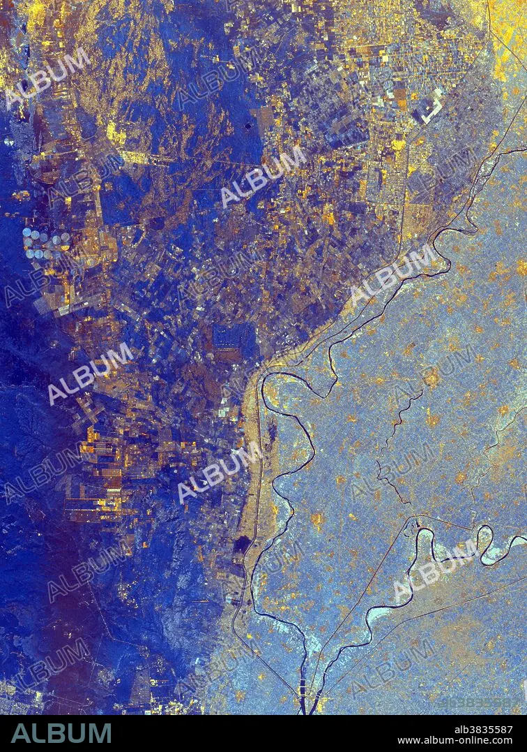
This spaceborne radar image shows the area just north of the city of Cairo, Egypt, where the Nile River splits into two main branches. The Rosetta Branch is the curving dark line in the center of the image and the Damietta Branch is the curving dark line in the lower right of the image. The light blue area on the right half of the image is a portion of the Nile River Delta. The thinner, straighter lines and the small network of gold lines are irrigation canals. There are more than 10,000 kilometers of canals throughout the Nile Delta. A transition zone of irrigated fields is shown in blue and yellow between the irrigated delta and the surrounding desert. The desert is the dark blue area on the left side of the image lacking the pattern of irrigated fields. This image was acquired by the Spaceborne Imaging Radar-C/X-band Synthetic Aperture Radar (SIR-C/X-SAR) on October 4, 1994, onboard the space shuttle Endeavour.
Crédito:
Album / Science Source / NASA/JPL
Autorizaciones:
Modelo: No - Propiedad: No
¿Preguntas relacionadas con los derechos?
¿Preguntas relacionadas con los derechos?
Tamaño imagen:
2233 x 3024 px | 19.3 MB
Tamaño impresión:
18.9 x 25.6 cm | 7.4 x 10.1 in (300 dpi)
Palabras clave:
AEREO • AFRICA • CANAL DE RIEGO • DESIERTO • EGIPTO • FOTOGRAFIA AEREA • GEOGRAFIA • GEOLOGIA • NILE • NILO (RIO) • NILO • RIO NILO • RIO
