alb3816425
Map of the Old World
| Compartir |
|---|
 Pinterest Pinterest |
 Twitter Twitter |
 Facebook Facebook |
 Copiar enlace Copiar enlace |
 Email Email |
|
Añadir a otro lightbox |
|
Añadir a otro lightbox |


¿Ya tienes cuenta? Iniciar sesión
¿No tienes cuenta? Regístrate
Compra esta imagen.
Selecciona el uso:

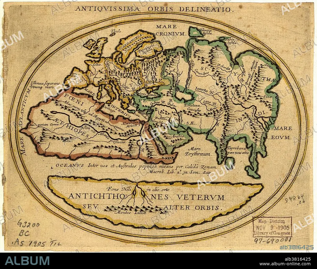
Título: Map of the Old World
Descripción:
Traducción automática: Mapa del Viejo Mundo con texto en latín. El título es Antiquissima Orbis Delineatio (mapa del mundo antiguo). El nivel de conocimiento geográfico es similar al del siglo XV. El mapa muestra: Europa (amarillo), Norte de África (rojo), Asia centro-occidental (verde) y una zona sur (amarillo, Antichthones: antípodas). Las regiones nombradas incluyen: Mare Interius (mar medio: Mediterráneo), Mare Eoum (mar oriental), Scythae (Scythia: Asia central), Persae (Persia) e Indi (India). Se muestran bosques, montañas y ríos. El ecuador es un océano de agua cálida. El Nilo tiene un brazo occidental y otro sur; este último procedente de las Montañas de la Luna (Montes Lunae). Catalogado: Biblioteca del Congreso de EE. UU. (1905)
Map of the Old World with Latin text. The title is Antiquissima Orbis Delineatio (ancient world map). The level of geographical knowledge is similar to that until the 15th century. The map shows: Europe (yellow), North Africa (red), West-Central Asia (green) and a southern area (yellow, Antichthones: antipodes). Named regions include: Mare Interius (middle sea: Mediterranean), Mare Eoum (eastern sea), Scythae (Scythia: Central Asia), Persae (Persia) and Indi (India). Forests, mountains and rivers are shown. The equator is an ocean of warm water. The Nile has a western and southern branch; the latter from the Mountains of the Moon (Montes Lunae). Catalogued: US Library of Congress (1905).
Crédito: Album / Science Source / LOC/Geography and Map Division
Autorizaciones: ? Cesión de modelo: No - ? Cesión de propiedad: No
¿Preguntas relacionadas con los derechos?
¿Preguntas relacionadas con los derechos?
Tamaño imagen: 2468 × 1971 px | 13.9 MB
Tamaño impresión: 20.9 × 16.7 cm | 971.7 × 776.0 in (300 dpi)
Palabras clave: AFRICA • ANTIGUO • ANTIGÜEDAD • ASIA • CARTOGRAFIA • CONTINENTE • CONTINENTES • DIAGRAMA • EDAD MEDIA • EUROPA • GEOGRAFIA • GEOGRAFICO • HISTORIA • HISTORICO • HORIZONTAL • ILUSTRACION • ILUSTRACIONES • INCOMPLETO • INEXACTA • MAPA • MEDIEVAL • MUNDO • OBRA DE ARTE • PAISAJE • PAISAJES • VIEJO MUNDO
