alb5486609
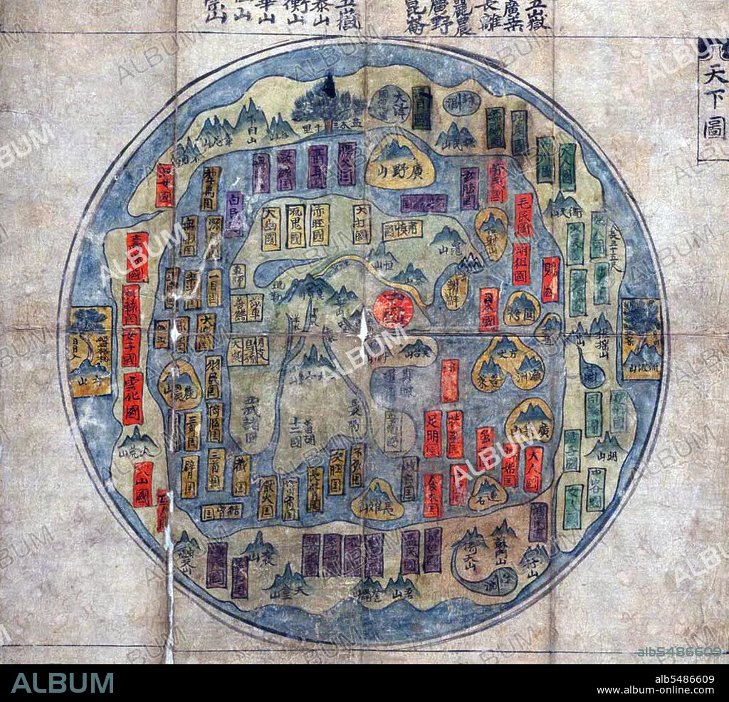
Map of the World ('Tian Xia Tu', or 'Map of All Under Heaven') showing China, the 'Middle Kingdom', as the centre of the world. Korea, mid-18th century.
| Compartir |
|---|
 Pinterest Pinterest |
 Twitter Twitter |
 Facebook Facebook |
 Copiar enlace Copiar enlace |
 Email Email |
|
Añadir a otro lightbox |
|
Añadir a otro lightbox |


¿Ya tienes cuenta? Iniciar sesión
¿No tienes cuenta? Regístrate
Compra esta imagen.
Selecciona el uso:

Título: Map of the World ('Tian Xia Tu', or 'Map of All Under Heaven') showing China, the 'Middle Kingdom', as the centre of the world. Korea, mid-18th century.
Descripción:
Traducción automática: Este Chonhado (mapa de todo lo que hay bajo el cielo), fue elaborado en Corea en el siglo XVIII. El mapa proviene de la tradición budista de China con datos de posiblemente 2000 años de antigüedad, aunque los ejemplos más antiguos que se conservan datan del siglo XVI. A partir de ese momento, el estilo ganó popularidad en Corea y, a finales del siglo XIX, existían numerosas copias. La estructura del mapa es simple. Un continente principal, que contiene a China, Corea y varios países históricamente conocidos, ocupa el centro del mapa circular, rodeado por un anillo marino circundante, que a su vez está rodeado por un anillo exterior de tierra.
This Chonhado (map of all under heaven), was produced in Korea in the 18th century. The map comes out of the Buddhist tradition of China with data possibly 2000 years old, although the earliest-known surviving examples date from the sixteenth century. From that time, the style gained popularity in Korea, and by the end of the nineteenth century numerous copies existed. The structure of the map is simple. A main continent, containing China, Korea, and a number of historically known countries, occupies the center of the circular map, surrounded by an enclosing sea ring, which is itself surrounded by an outerring of land.
Crédito: Album / Pictures From History/Universal Images Group
Autorizaciones: ? Cesión de modelo: No - ? Cesión de propiedad: No
¿Preguntas relacionadas con los derechos?
¿Preguntas relacionadas con los derechos?
Tamaño imagen: 4242 × 3863 px | 46.9 MB
Tamaño impresión: 35.9 × 32.7 cm | 1670.1 × 1520.9 in (300 dpi)
