alb8370463
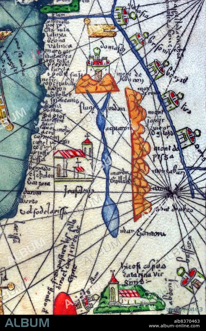
Spain / Catalonia: Israel, Palestine and Jordan as represented in the Catalan Atlas, by the Jewish illustrator Cresques Abraham,1375
| Compartir |
|---|
 Pinterest Pinterest |
 Twitter Twitter |
 Facebook Facebook |
 Copiar enlace Copiar enlace |
 Email Email |
|
Añadir a otro lightbox |
|
Añadir a otro lightbox |


¿Ya tienes cuenta? Iniciar sesión
¿No tienes cuenta? Regístrate
Compra esta imagen.
Selecciona el uso:

Título: Spain / Catalonia: Israel, Palestine and Jordan as represented in the Catalan Atlas, by the Jewish illustrator Cresques Abraham,1375
Descripción: Ver traducción automática
The Catalan Atlas (1375) is the most important Catalan map of the medieval period. It was produced by the Majorcan cartographic school and is attributed to Cresques Abraham, a Jewish book illuminator who was self-described as being a master of the maps of the world as well as compasses. It has been in the royal library of France (now the Bibliotheque nationale de France) since the late 14th century.
The Catalan Atlas (1375) is the most important Catalan map of the medieval period. It was produced by the Majorcan cartographic school and is attributed to Cresques Abraham, a Jewish book illuminator who was self-described as being a master of the maps of the world as well as compasses. It has been in the royal library of France (now the Bibliotheque nationale de France) since the late 14th century.
Crédito: Album / Universal Images Group / Pictures From History
Autorizaciones: ? Cesión de modelo: No - ? Cesión de propiedad: No
¿Preguntas relacionadas con los derechos?
¿Preguntas relacionadas con los derechos?
Tamaño imagen: 3337 × 5100 px | 48.7 MB
Tamaño impresión: 28.3 × 43.2 cm | 1313.8 × 2007.9 in (300 dpi)
Palabras clave: ABRAHAM CRESQUES • AFRICA • ART • ARTE • ARTES • ATLAS CATALAN • ATLAS • BOTE DE ESPECIAS • CARTOGRAFIA • CATALAN • CATALUNA • CATALUNYA • CATALUÑA • COMERCIO • DAVID • ESPAÑA • ESPAÑOL • ESPAÑOLA • ESPAÑOLES • ESPECIA • ESPECIAS • EXPLORACION • ISRAEL • LATA DE ESPECIES • MAPA • MAPAS • MINIATURA • PALESTINA • PINTURA • RIACHUELO • RIO • RIOS • S. XIV • SIGLO XIV • SPAIN • TRAVESIA • TRAYECTO • VIAJAR • VIAJE • VIAJES
