alb9475170
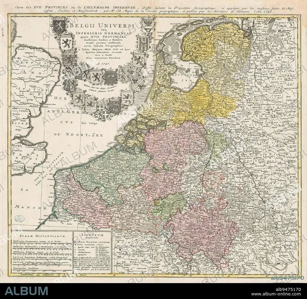
Map of the Seventeen Provinces, Belgii Universi seu Inferioris Germaniae quam XVII Provinciae ... / Carte des XVII Provinces ou de l'Allemagne Inferieure ... (title on object), Top left title surrounded by the arms of the Seventeen Provinces. Bottom left six scale bars: Milliaria Germanica comm. 15 in gradu; Milliaria Hollandia et Brabantica 20 in gradu; and four others. In addition, legend and explanatory notes. The map has a coordinate net and a degree division along the edges., print maker: Ruprecht Adam Schneider, (mentioned on object), Johann Tobias Mayer, (mentioned on object), publisher: erven Johann Baptista Homann, (mentioned on object), print maker: Fürth, Neurenberg, publisher: Neurenberg, 1747 and/or 1748, paper, engraving, height 497 mm × width 546 mm.
| Compartir |
|---|
 Pinterest Pinterest |
 Twitter Twitter |
 Facebook Facebook |
 Copiar enlace Copiar enlace |
 Email Email |
|
Añadir a otro lightbox |
|
Añadir a otro lightbox |


¿Ya tienes cuenta? Iniciar sesión
¿No tienes cuenta? Regístrate
Compra esta imagen.
Selecciona el uso:

Descripción: Ver traducción automática
Map of the Seventeen Provinces, Belgii Universi seu Inferioris Germaniae quam XVII Provinciae ... / Carte des XVII Provinces ou de l'Allemagne Inferieure ... (title on object), Top left title surrounded by the arms of the Seventeen Provinces. Bottom left six scale bars: Milliaria Germanica comm. 15 in gradu; Milliaria Hollandia et Brabantica 20 in gradu; and four others. In addition, legend and explanatory notes. The map has a coordinate net and a degree division along the edges., print maker: Ruprecht Adam Schneider, (mentioned on object), Johann Tobias Mayer, (mentioned on object), publisher: erven Johann Baptista Homann, (mentioned on object), print maker: Fürth, Neurenberg, publisher: Neurenberg, 1747 and/or 1748, paper, engraving, height 497 mm × width 546 mm
Map of the Seventeen Provinces, Belgii Universi seu Inferioris Germaniae quam XVII Provinciae ... / Carte des XVII Provinces ou de l'Allemagne Inferieure ... (title on object), Top left title surrounded by the arms of the Seventeen Provinces. Bottom left six scale bars: Milliaria Germanica comm. 15 in gradu; Milliaria Hollandia et Brabantica 20 in gradu; and four others. In addition, legend and explanatory notes. The map has a coordinate net and a degree division along the edges., print maker: Ruprecht Adam Schneider, (mentioned on object), Johann Tobias Mayer, (mentioned on object), publisher: erven Johann Baptista Homann, (mentioned on object), print maker: Fürth, Neurenberg, publisher: Neurenberg, 1747 and/or 1748, paper, engraving, height 497 mm × width 546 mm
Crédito: Album / quintlox
Autorizaciones: ? Cesión de modelo: No - ? Cesión de propiedad: No
¿Preguntas relacionadas con los derechos?
¿Preguntas relacionadas con los derechos?
Tamaño imagen: 4672 × 4309 px | 57.6 MB
Tamaño impresión: 39.6 × 36.5 cm | 1839.4 × 1696.5 in (300 dpi)
