alb9838905
NICOLAES VISSCHER. Map of North Holland, c.1700-c.1710. Creator: Nicolaes Visscher.
| Compartir |
|---|
 Pinterest Pinterest |
 Twitter Twitter |
 Facebook Facebook |
 Copiar enlace Copiar enlace |
 Email Email |
|
Añadir a otro lightbox |
|
Añadir a otro lightbox |


¿Ya tienes cuenta? Iniciar sesión
¿No tienes cuenta? Regístrate
Compra esta imagen.
Selecciona el uso:

Autor:
Título:
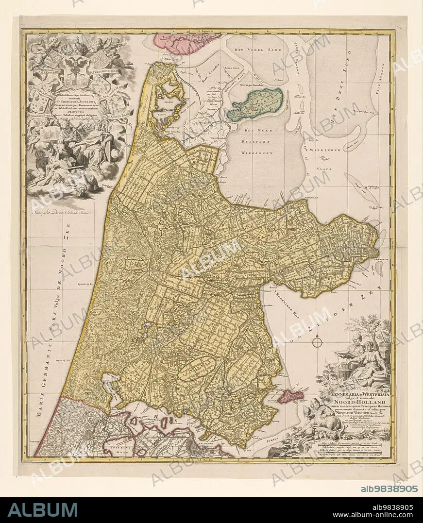
Map of North Holland, c.1700-c.1710. Creator: Nicolaes Visscher.
Descripción:
Ver traducción automática
Map of North Holland, c.1700-c.1710. 'Kennemaria et Westfrisia vulgo et vernaculé Noord-Holland tam in minores quam Praecipuas Ditiones...'. Showing the southern tip of Texel, Wieringen, Marken and a small section of South Holland. At the bottom right scale in German and French miles (1: 150,000). At the bottom right the title, farmers with cheeses, butter and milk. At top left, dedication and putti with the imperial crown and coat of arms, allegorical figures - one holding a windmill looking at an image of a lock.
Personas:
Crédito:
Album / Heritage Art/Heritage Images
Autorizaciones:
Tamaño imagen:
4748 x 5584 px | 75.9 MB
Tamaño impresión:
40.2 x 47.3 cm | 15.8 x 18.6 in (300 dpi)
Palabras clave:
ACUARELA • AGUILA BICEFALA • ANGELICAL • ANIMAL • ARENA • ARTE • ARTES • AVES • BEBER • CANAL • CANALES • CIERRES • COLOR • COLORIDO • COMIDA • CONCEPTO • CORNUCOPIA • COSTA • CUERNO DE LA ABUNDANCIA • DISEÑO • EDIFICIO • ESCUDO DE ARMAS • EUROPA • GEOGRAFIA • GRABADO • HERÁLDICO • HOLANDES • IMPERIO • IMPRESION • INGENIERIA CIVIL • INGENIERÍA • ISLA • ISLAS • LÁCTEOS • LECHE • LITORAL • MAPA • MAR DEL NORTE • MAR • MITOLOGIA • MOLINO • MUSEO • NATURALEZA • NICOLAES VISSCHER • NICOLAES • PAISES BAJOS • PAJARO • PAPEL • PIETER SCHENK • PUTTI • PUTTO • QUERUBIN • QUERUBINES • RAPACES • RIJKSMUSEUM • RIO • RIOS • S. XVIII • SACRO IMPERIO ALEMAN • SACRO IMPERIO ROMANO GERMANICO • SIGLO XVIII • SIGLO • TRANSPORTE ACUATICO • TRANSPORTE
