alb3800434
After Fall of Roman Empire, 5th Century
| Compartir |
|---|
 Pinterest Pinterest |
 Twitter Twitter |
 Facebook Facebook |
 Copiar enlace Copiar enlace |
 Email Email |
|
Añadir a otro lightbox |
|
Añadir a otro lightbox |


¿Ya tienes cuenta? Iniciar sesión
¿No tienes cuenta? Regístrate
Compra esta imagen.
Selecciona el uso:

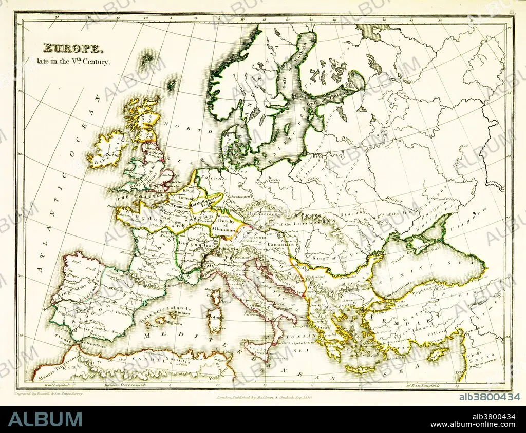
Título: After Fall of Roman Empire, 5th Century
Descripción:
Traducción automática: Un mapa de Europa, que muestra las fronteras territoriales existentes en el siglo V, después de que el Imperio Romano Occidental se derrumbara efectivamente. Para el año 476 EC, cuando Odoacro depuso al emperador Rómulo, el Imperio Romano Occidental ejercía un poder militar, político o financiero insignificante y no tenía control efectivo sobre los dominios occidentales dispersos que aún podían describirse como romanos. Mapa publicado en 1831
A map of Europe, showing territorial borders existing in the 5th century, after the Western Roman Empire had effectively collapsed. By 476 CE, when Odoacer deposed the Emperor Romulus, the Western Roman Empire wielded negligible military, political, or financial power and had no effective control over the scattered Western domains that could still be described as Roman. Map published in 1831.
Crédito: Album / Science Source / British Library
Autorizaciones: ? Cesión de modelo: No - ? Cesión de propiedad: No
¿Preguntas relacionadas con los derechos?
¿Preguntas relacionadas con los derechos?
Tamaño imagen: 3543 × 2736 px | 27.7 MB
Tamaño impresión: 30.0 × 23.2 cm | 1394.9 × 1077.2 in (300 dpi)
Palabras clave: ANTIGUO • ANTIGÜEDAD • ARTE • ASIGNACIÓN • CARTOGRAFIA • CIVILIZACION ANTIGUA • CULTURA ANTIGUA • DIBUJO • EUROPA • EUROPEA • EUROPEAS • EUROPEO • EUROPEOS • FAMOSA • FAMOSO • FAMOSOS • GEOGRAFIA • GEOGRAFICA • GEOGRAFICO • HISTORIA • HISTORICO • ILUSTRACION • ILUSTRACIONES • IMPERIO ROMANO • IMPORTANTE • MAPA • OBRA DE ARTE • ROMANO • S. -V • S. V • SIGLO V
