alb3804267
Dürer Star Map, 1515
| Compartir |
|---|
 Pinterest Pinterest |
 Twitter Twitter |
 Facebook Facebook |
 Copiar enlace Copiar enlace |
 Email Email |
|
Añadir a otro lightbox |
|
Añadir a otro lightbox |


¿Ya tienes cuenta? Iniciar sesión
¿No tienes cuenta? Regístrate
Compra esta imagen.
Selecciona el uso:

Título: Dürer Star Map, 1515
Descripción: Ver traducción automática
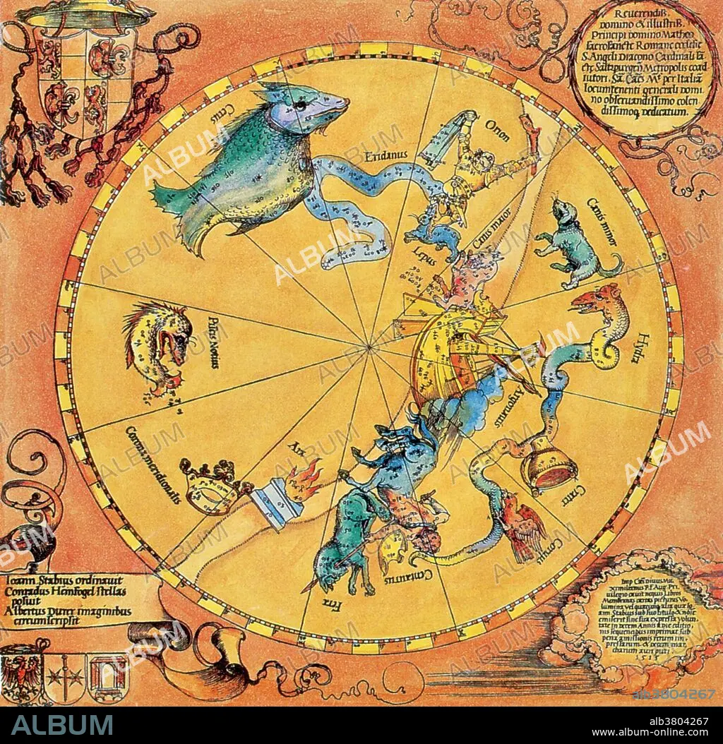
Map of the Southern Sky, with representations of constellations, decorated with the crest of Cardinal Lang von Wellenburg, and a dedication to him with his coats of arms and the Imperial copyright. t is one of the oldest European printed star charts produced by Dürer in 1515. A star chart or star map is a map of the night sky. Astronomers divide these into grids to use them more easily. They are used to identify and locate astronomical objects such as stars, constellations and galaxies. They have been used for human navigation since time immemorial. Albrecht Dürer (May 21, 1471 - April 6, 1528) was a German painter, engraver, printmaker, mathematician, and theorist. His woodcuts established his reputation and influence across Europe when he was still in his twenties, and he has been conventionally regarded as the greatest artist of the Northern Renaissance ever since. He died in 1528 at the age of 56.
Map of the Southern Sky, with representations of constellations, decorated with the crest of Cardinal Lang von Wellenburg, and a dedication to him with his coats of arms and the Imperial copyright. t is one of the oldest European printed star charts produced by Dürer in 1515. A star chart or star map is a map of the night sky. Astronomers divide these into grids to use them more easily. They are used to identify and locate astronomical objects such as stars, constellations and galaxies. They have been used for human navigation since time immemorial. Albrecht Dürer (May 21, 1471 - April 6, 1528) was a German painter, engraver, printmaker, mathematician, and theorist. His woodcuts established his reputation and influence across Europe when he was still in his twenties, and he has been conventionally regarded as the greatest artist of the Northern Renaissance ever since. He died in 1528 at the age of 56.
Personas: ALBRECHT DURER (1471-1528)
Crédito: Album / Science Source / New York Public Library
Autorizaciones: ? Cesión de modelo: No - ? Cesión de propiedad: No
¿Preguntas relacionadas con los derechos?
¿Preguntas relacionadas con los derechos?
Tamaño imagen: 3511 × 3431 px | 34.5 MB
Tamaño impresión: 29.7 × 29.0 cm | 1382.3 × 1350.8 in (300 dpi)
Palabras clave: ALBRECHT DURER • ARTE • ASTROLOGIA • ASTROLOGICO • ASTRONOMIA • ASTRONÓMICO • CELESTE • CELESTIAL SPHERE • CELESTIAL • CIENCIA • CUERPO CELESTE • DIBUJO • ESFERA CELESTE • FAMOSA • FAMOSO • FAMOSOS • GRABADO EN MADERA • HISTORIA • HISTORICO • ILUSTRACION • ILUSTRACIONES • IMPORTANTE • OBRA DE ARTE • PLANCHA DE MADERA • S. XVI • SIGLO XVI • SIGNOS DEL ZODIACO • XILOGRAFIA • ZODIACO
