alb9396160
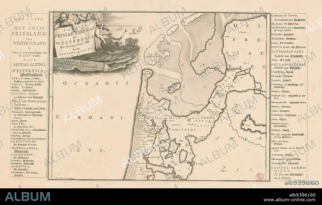
Historical map of the Netherlands with the territories of the Batavians and Frisians, Pars I Frisiae Liberae quae Westfresia (...) / The I part of the Free Friesland. Which Westfriesland is (...) (title on object), Map of Frisian areas in West Friesland in Roman times. Top left cartouche with title, above two putti. To the right of cartouche in background Neptune and several tritons. Scale stick below cartouche: Quadrans gradus. Degrees along left and right edges. Left and right of print strips of letterpress text with Dutch translation of title (upper left) and terms used on map., print maker: Gerrit de Broen (I), (mentioned on object), print maker: Joseph Mulder, (mentioned on object), after own design by: Joseph Mulder, (mentioned on object), print maker: Amsterdam, print maker: Netherlands, 1697 - 1700 and/or 1718 and/or 1725, paper, engraving, etching, letterpress printing, height 321 mm × width 422 mm, height 321 mm × width 556 mm.
| Compartir |
|---|
 Pinterest Pinterest |
 Twitter Twitter |
 Facebook Facebook |
 Copiar enlace Copiar enlace |
 Email Email |
|
Añadir a otro lightbox |
|
Añadir a otro lightbox |


¿Ya tienes cuenta? Iniciar sesión
¿No tienes cuenta? Regístrate
Compra esta imagen.
Selecciona el uso:

Descripción: Ver traducción automática
Historical map of the Netherlands with the territories of the Batavians and Frisians, Pars I Frisiae Liberae quae Westfresia (...) / The I part of the Free Friesland. Which Westfriesland is (...) (title on object), Map of Frisian areas in West Friesland in Roman times. Top left cartouche with title, above two putti. To the right of cartouche in background Neptune and several tritons. Scale stick below cartouche: Quadrans gradus. Degrees along left and right edges. Left and right of print strips of letterpress text with Dutch translation of title (upper left) and terms used on map., print maker: Gerrit de Broen (I), (mentioned on object), print maker: Joseph Mulder, (mentioned on object), after own design by: Joseph Mulder, (mentioned on object), print maker: Amsterdam, print maker: Netherlands, 1697 - 1700 and/or 1718 and/or 1725, paper, engraving, etching, letterpress printing, height 321 mm × width 422 mm, height 321 mm × width 556 mm
Historical map of the Netherlands with the territories of the Batavians and Frisians, Pars I Frisiae Liberae quae Westfresia (...) / The I part of the Free Friesland. Which Westfriesland is (...) (title on object), Map of Frisian areas in West Friesland in Roman times. Top left cartouche with title, above two putti. To the right of cartouche in background Neptune and several tritons. Scale stick below cartouche: Quadrans gradus. Degrees along left and right edges. Left and right of print strips of letterpress text with Dutch translation of title (upper left) and terms used on map., print maker: Gerrit de Broen (I), (mentioned on object), print maker: Joseph Mulder, (mentioned on object), after own design by: Joseph Mulder, (mentioned on object), print maker: Amsterdam, print maker: Netherlands, 1697 - 1700 and/or 1718 and/or 1725, paper, engraving, etching, letterpress printing, height 321 mm × width 422 mm, height 321 mm × width 556 mm
Crédito: Album / quintlox
Autorizaciones: ? Cesión de modelo: No - ? Cesión de propiedad: No
¿Preguntas relacionadas con los derechos?
¿Preguntas relacionadas con los derechos?
Tamaño imagen: 5120 × 2994 px | 43.9 MB
Tamaño impresión: 43.3 × 25.3 cm | 2015.7 × 1178.7 in (300 dpi)
Palabras clave: 1697 • 1718 • AGUAFUERTE • AMSTERDAM • ENGRAVING • GRABADO • GRABADOS • GRADOS • IZQUIERDA • MAPA HISTORICO • MAPA • MAPAS • OBJETO • PAISES BAJOS • PAPEL • TERRITORIOS
