alb3799698
Map of Tenochtitlan, 1524
| Compartir |
|---|
 Pinterest Pinterest |
 Twitter Twitter |
 Facebook Facebook |
 Copiar enlace Copiar enlace |
 Email Email |
|
Añadir a otro lightbox |
|
Añadir a otro lightbox |


¿Ya tienes cuenta? Iniciar sesión
¿No tienes cuenta? Regístrate
Compra esta imagen.
Selecciona el uso:

Título: Map of Tenochtitlan, 1524
Descripción: Ver traducción automática
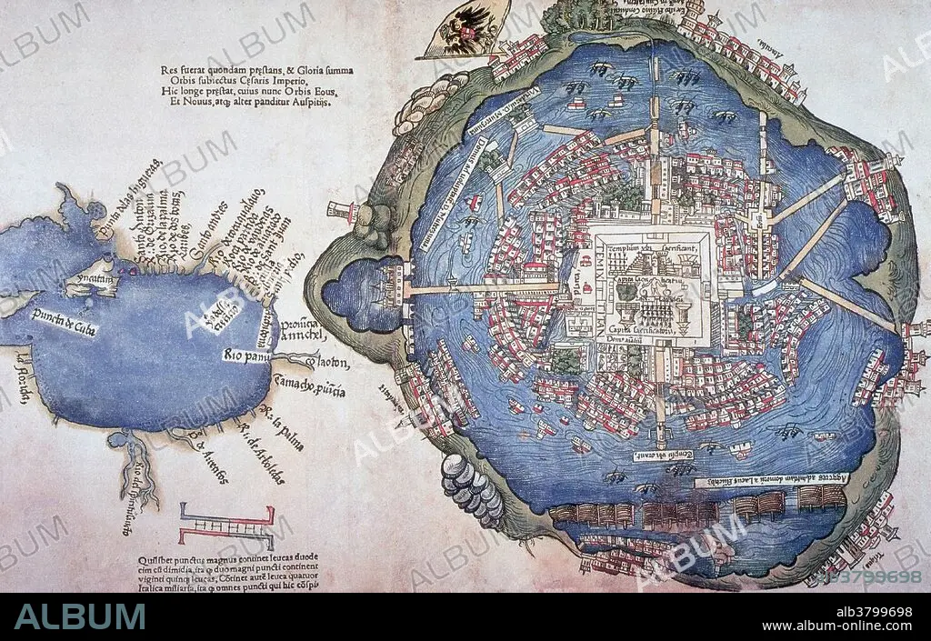
Map of Tenochtitlan, printed 1524 in Nuremberg, Germany by Friedrich Peypus, probably after drawing made by one of Cortez' men. Mexico-Tenochtitlan, commonly known as Tenochtitlan, was an Aztec altepetl (city-state) located on an island in Lake Texcoco, in the Valley of Mexico. Founded in 1325, a thriving culture developed, and the Mexica civilization came to dominate other tribes around Mexico. The small natural island was perpetually enlarged as Tenochtitlan grew to become the largest and most powerful city in Mesoamerica. The city was connected to the mainland by causeways leading to the north, south, and west. The causeways were interrupted by bridges that allowed canoes and other traffic to pass freely. The bridges could be pulled away, if necessary, to defend the city. The city was interlaced with a series of canals, so that all sections of the city could be visited either on foot or via canoe. It was captured by the Spanish in 1521. Today the ruins of Tenochtitlan are located in Mexico City's downtown.
Map of Tenochtitlan, printed 1524 in Nuremberg, Germany by Friedrich Peypus, probably after drawing made by one of Cortez' men. Mexico-Tenochtitlan, commonly known as Tenochtitlan, was an Aztec altepetl (city-state) located on an island in Lake Texcoco, in the Valley of Mexico. Founded in 1325, a thriving culture developed, and the Mexica civilization came to dominate other tribes around Mexico. The small natural island was perpetually enlarged as Tenochtitlan grew to become the largest and most powerful city in Mesoamerica. The city was connected to the mainland by causeways leading to the north, south, and west. The causeways were interrupted by bridges that allowed canoes and other traffic to pass freely. The bridges could be pulled away, if necessary, to defend the city. The city was interlaced with a series of canals, so that all sections of the city could be visited either on foot or via canoe. It was captured by the Spanish in 1521. Today the ruins of Tenochtitlan are located in Mexico City's downtown.
Personas: AZTEC
Crédito: Album / Science Source
Autorizaciones: ? Cesión de modelo: No - ? Cesión de propiedad: No
¿Preguntas relacionadas con los derechos?
¿Preguntas relacionadas con los derechos?
Tamaño imagen: 4650 × 2962 px | 39.4 MB
Tamaño impresión: 39.4 × 25.1 cm | 1830.7 × 1166.1 in (300 dpi)
Palabras clave: 1524 • AMERICA CENTRAL • ARTE • AZTEC • CIUDAD CAPITAL • CIVILIZACION ANTIGUA • CIVILIZACIÓN AZTECA • CULTURA ANTIGUA • DIBUJO • FAMOSA • FAMOSO • FAMOSOS • HISTORIA • HISTORICO • ILUSTRACION • ILUSTRACIONES • IMPORTANTE • MESOAMERICA • MEXICO • MEXICO-TENOCHTITLAN • MOTECUHZOMA XOCOYOTZIN • NAHUATL • OBRA DE ARTE • S. XVI • SIGLO XVI • SÍTIO • TEMPLO • TENOCHTITLAN
