alb3800902
WWI, Satirical War Map of Europe, 1914
| Compartir |
|---|
 Pinterest Pinterest |
 Twitter Twitter |
 Facebook Facebook |
 Copiar enlace Copiar enlace |
 Email Email |
|
Añadir a otro lightbox |
|
Añadir a otro lightbox |


¿Ya tienes cuenta? Iniciar sesión
¿No tienes cuenta? Regístrate
Compra esta imagen.
Selecciona el uso:

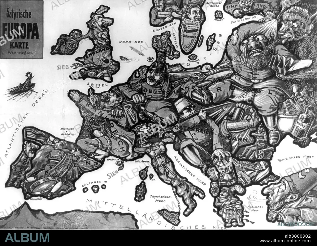
Título: WWI, Satirical War Map of Europe, 1914
Descripción:
Traducción automática: Titulado: Satyrische Europa Karte Weltkrieg 1914. Boceto que representa un mapa de Europa al estallar la Primera Guerra Mundial, con cada país representado como una figura humana representativa del estado de cosas o actitudes particulares del país; por ejemplo, Alemania está representada como un soldado que lucha contra Rusia y Francia, mientras mira a Inglaterra.
Entitled: Satyrische Europa Karte Weltkrieg 1914. Sketch depicting a map of Europe at the outbreak of the first World War with each country depicted as a human figure representative of the particular state of affairs or attitudes of the country, for instance, Germany is depicted as a soldier fighting with both Russia and France, while eyeing England.
Crédito: Album / LOC/Science Source
Autorizaciones: ? Cesión de modelo: No - ? Cesión de propiedad: No
¿Preguntas relacionadas con los derechos?
¿Preguntas relacionadas con los derechos?
Tamaño imagen: 4800 × 3475 px | 47.7 MB
Tamaño impresión: 40.6 × 29.4 cm | 1889.8 × 1368.1 in (300 dpi)
Palabras clave: 1914 • 1ª GUERRA MUNDIAL • ACONTECIMIENTO • ALEMANIA • ARTE • BLANCO Y NEGRO • CARICATURA • DIBUJO • ESCOCIA • ESPANA • ESPAÑA • EUROPA • FAMOSA • FAMOSO • FAMOSOS • FRANCIA • FRENTE OESTE • GRAN BRETAÑA • GRAN GUERRA • GUERRA MUNDIAL I 1914/18 • GUERRA MUNDIAL I • HISTORIA • HISTORICO • HOMBRE • HOMBRES • ILUSTRACION • ILUSTRACIONES • IMPORTANTE • INGLATERRA • IRLANDA • ITALIA • MAPA • MASCULINO • OBRA DE ARTE • PAVO COMÚN (MELEAGRIS GALLOPAVO) • PRIMERA GUERRA MUNDIAL 1914/18 • PRIMERA GUERRA MUNDIAL • RETRATO DE HOMBRE • RUSIA • S. XX • SATIRA • SATÍRICO • SIGLO XX • SOLDADO • SUECIA • WW1
