alb3832471
weather radar
| Compartir |
|---|
 Pinterest Pinterest |
 Twitter Twitter |
 Facebook Facebook |
 Copiar enlace Copiar enlace |
 Email Email |
|
Añadir a otro lightbox |
|
Añadir a otro lightbox |


¿Ya tienes cuenta? Iniciar sesión
¿No tienes cuenta? Regístrate
Compra esta imagen.
Selecciona el uso:

Título: weather radar
Descripción:
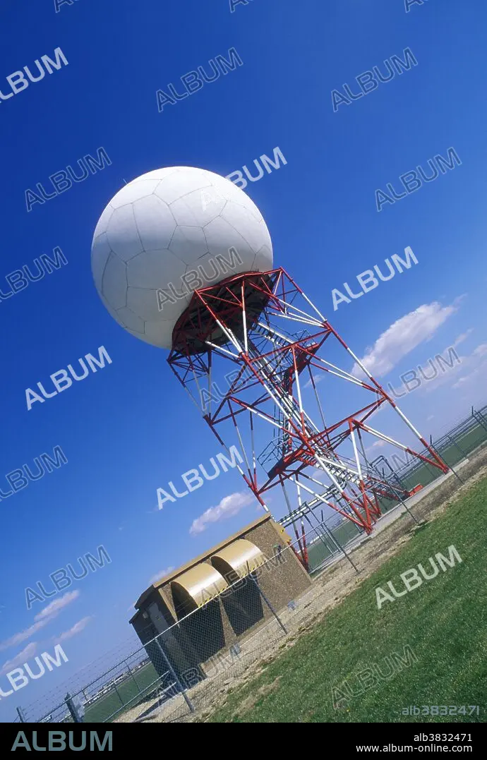
Traducción automática: Radar meteorológico. Domo de radar Doppler (modelo WSR-88D) para previsión meteorológica. Esta tecnología permite a los pronosticadores comprender los cambios en el clima y predecir lo que sucederá en el futuro cercano. Las ondas de radio emitidas por una antena se dispersan o reflejan por fenómenos atmosféricos como gotas de lluvia, cristales de nieve o granizo. Las ondas de radio que regresan son recibidas por la cúpula geodésica y se convierten electrónicamente en imágenes que muestran la ubicación y el movimiento de los sistemas meteorológicos. La dirección y velocidad del viento se pueden derivar de cambios en la frecuencia de las ondas de radio. Fotografiado en el Servicio Meteorológico Nacional en Wichita, Kansas, EE.UU.
Weather radar. Doppler radar dome (model WSR-88D) for weather forecasting. This technology allows forecasters to understand changes in the weather and to predict what will happen in the near future. Radio waves emitted from an antenna are scattered or reflected from atmospheric phenomena such as rain drops, snow crystals or hail pellets. The returning radio waves are received by the geodesic dome and are converted electronically into pictures showing the location and movement of weather systems. The direction and speed of wind can be derived from changes in frequency of the radio waves. Photographed at the National Weather Service in Wichita, Kansas, USA.
Crédito: Album / Science Source / Jim Reed
Autorizaciones: ? Cesión de modelo: No - ? Cesión de propiedad: No
¿Preguntas relacionadas con los derechos?
¿Preguntas relacionadas con los derechos?
Tamaño imagen: 3562 × 5288 px | 53.9 MB
Tamaño impresión: 30.2 × 44.8 cm | 1402.4 × 2081.9 in (300 dpi)
Palabras clave: AMERICA • AMERICANO • ATMOSFERA • CLIMA • DE VIGILANCIA • DOPPLER • EDIFICIO • EQUIPAMIENTO • EQUIPO • ESFERA • ESTADOS UNIDOS DE AMERICA • ESTADOS UNIDOS • GEODESICO • KANSAS • METEOROLOGÍA • METEOROLÓGICO • METEREOLOGIA • METEREOLÓGICOS • NACIONAL • PREVISION • SERVICIO • VERTICAL
