alb3818051
Planisphere Coeleste, Star Map, 1680
| Compartir |
|---|
 Pinterest Pinterest |
 Twitter Twitter |
 Facebook Facebook |
 Copiar enlace Copiar enlace |
 Email Email |
|
Añadir a otro lightbox |
|
Añadir a otro lightbox |


¿Ya tienes cuenta? Iniciar sesión
¿No tienes cuenta? Regístrate
Compra esta imagen.
Selecciona el uso:

Título: Planisphere Coeleste, Star Map, 1680
Descripción: Ver traducción automática
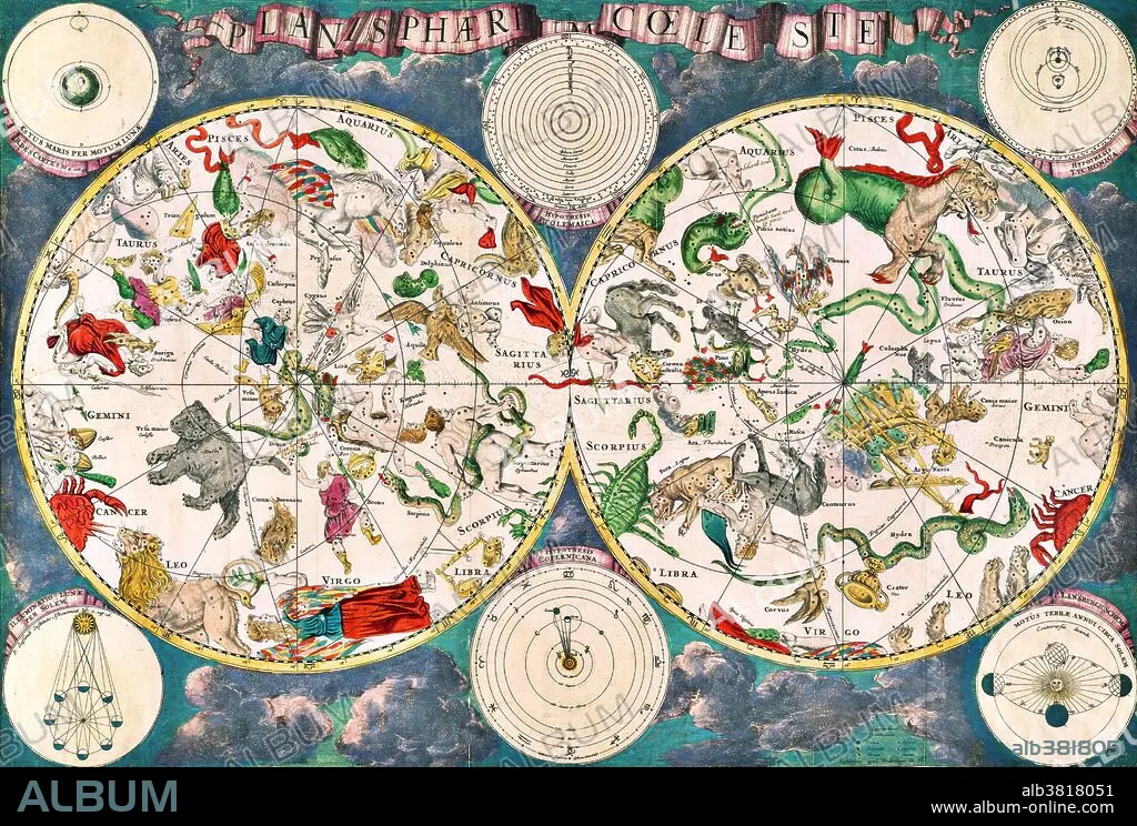
Planisphaeri coeleste, 1680, a celestial planisphere featuring the constellations of the northern and southern hemispheres with traditional representations of the signs of the Zodiac and constellations, including Draco, Serpens and Hydra. Astronomy and celestial star chart map by the Dutch cartographer family Frederik de Wit. A star chart or star map is a map of the night sky. Astronomers divide these into grids to use them more easily. They are used to identify and locate astronomical objects such as stars, constellations and galaxies. They have been used for human navigation since time immemorial. A planisphere is a type of star chart. The Atlas Coelestis is a star atlas published posthumously in 1729, based on observations made by the First Astronomer Royal, John Flamsteed.
Planisphaeri coeleste, 1680, a celestial planisphere featuring the constellations of the northern and southern hemispheres with traditional representations of the signs of the Zodiac and constellations, including Draco, Serpens and Hydra. Astronomy and celestial star chart map by the Dutch cartographer family Frederik de Wit. A star chart or star map is a map of the night sky. Astronomers divide these into grids to use them more easily. They are used to identify and locate astronomical objects such as stars, constellations and galaxies. They have been used for human navigation since time immemorial. A planisphere is a type of star chart. The Atlas Coelestis is a star atlas published posthumously in 1729, based on observations made by the First Astronomer Royal, John Flamsteed.
Crédito: Album / Science Source / New York Public Library
Autorizaciones: ? Cesión de modelo: No - ? Cesión de propiedad: No
¿Preguntas relacionadas con los derechos?
¿Preguntas relacionadas con los derechos?
Tamaño imagen: 4200 × 2836 px | 34.1 MB
Tamaño impresión: 35.6 × 24.0 cm | 1653.5 × 1116.5 in (300 dpi)
Palabras clave: 1680 • ACUARIO SIGNO DEL ZODIACO • ARIES • ASTROLOGIA • ASTROLOGICO • ASTRONOMIA • ASTRONÓMICO • CANCER • CAPRICORNIO (ZODIACO) • CAPRICORNIO • CELESTE • CELESTIAL SPHERE • CELESTIAL • CIENCIA • CUERPO CELESTE • DRACO • ESFERA CELESTE • FAMOSA • FAMOSO • FAMOSOS • HISTORIA • HISTORICO • IMPORTANTE • PISCIS • SERPENTARIO • SIGLO XVII • SIGNOS DEL ZODIACO • ZODIACO
