alb4057952
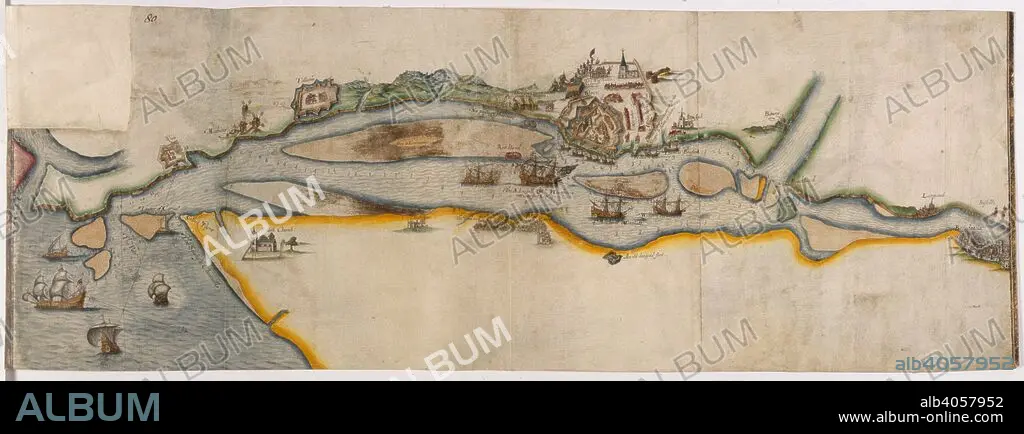
Map representing the course of the river Garonne from Bordeaux to the sea, with the town of Blaye besieged. 1593. Source: Cotton Augustus I.ii.80.
| Compartir |
|---|
 Pinterest Pinterest |
 Twitter Twitter |
 Facebook Facebook |
 Copiar enlace Copiar enlace |
 Email Email |
|
Añadir a otro lightbox |
|
Añadir a otro lightbox |


¿Ya tienes cuenta? Iniciar sesión
¿No tienes cuenta? Regístrate
Compra esta imagen.
Selecciona el uso:

Descripción:
Ver traducción automática
Map representing the course of the river Garonne from Bordeaux to the sea, with the town of Blaye besieged. 1593. Source: Cotton Augustus I.ii.80.
Crédito:
Album / British Library
Autorizaciones:
Modelo: No - Propiedad: No
¿Preguntas relacionadas con los derechos?
¿Preguntas relacionadas con los derechos?
Tamaño imagen:
7932 x 2948 px | 66.9 MB
Tamaño impresión:
67.2 x 25.0 cm | 26.4 x 9.8 in (300 dpi)
Palabras clave:
ASEDIO • BARCO • BATALLA • BATALLAS • CARTOGRAFIA • CARTOGRAFICO • COMBATE • CONFLICTO ARMADO • CONFLICTOS ARMADOS • EMBARCACION • EVENTO MILITAR • EVENTOS MILITARES • FRANCES • FRANCIA • LUCHA • MAPA • RIO • S. XVI • SIGLO XVI • TRANSPORTE
