alb8371502
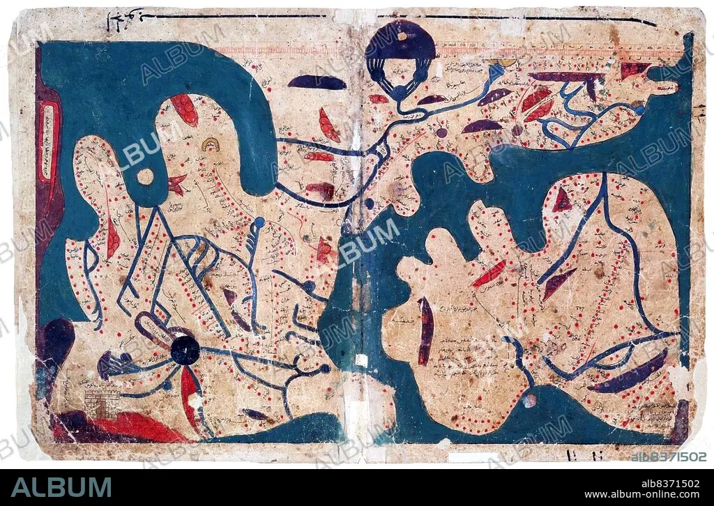
Egypt: Map of the world (south to the top), said to be the oldest rectangular map of the world, Kitab Ghara'ib al-funun wa-mulah al-'uyun< / i> ('The Book of Curiosities of the Sciences and Marvels for the Eyes'),12th-13th Centuries
| Compartir |
|---|
 Pinterest Pinterest |
 Twitter Twitter |
 Facebook Facebook |
 Copiar enlace Copiar enlace |
 Email Email |
|
Añadir a otro lightbox |
|
Añadir a otro lightbox |


¿Ya tienes cuenta? Iniciar sesión
¿No tienes cuenta? Regístrate
Compra esta imagen

Título:
Egypt: Map of the world (south to the top), said to be the oldest rectangular map of the world, Kitab Ghara'ib al-funun wa-mulah al-'uyun< / i> ('The Book of Curiosities of the Sciences and Marvels for the Eyes'),12th-13th Centuries
Descripción:
Ver traducción automática
Composed in Egypt in the first half of the 11th century, the 'Book of Curiosities' is a 12th/13th century cosmographical manuscript contains highly unique celestial and terrestrial maps, including the first known rectangular map of the world produced before the renaissance.
. The geographical references are based largely on the first century work of Ptolemy but the manuscript contains previously unknown distinct cartographic features.
. The geographical references are based largely on the first century work of Ptolemy but the manuscript contains previously unknown distinct cartographic features.
Crédito:
Album / Universal Images Group / Pictures From History
Autorizaciones:
Modelo: No - Propiedad: No
¿Preguntas relacionadas con los derechos?
¿Preguntas relacionadas con los derechos?
Tamaño imagen:
5100 x 3351 px | 48.9 MB
Tamaño impresión:
43.2 x 28.4 cm | 17.0 x 11.2 in (300 dpi)
Palabras clave:
ARABE • ART • ARTE • ARTES • ATLAS • CARTOGRAFIA • CIENCIA • CLAUDIO PTOLOMEO • EGIPCIA • EGIPCIAS • EGIPCIO • EGIPTO • GRAFICO • ISLAM • MAPA DEL MUNDO • MAPA MUNDI • MAPA • MAPAMUNDI • MAPPA MUNDI • MUSULMAN • ORIENTE MEDIO • PTOLOMEO • S. XII • S. XIII • SIGLO XII • SIGLO XIII • TARJETAS
