alb3800864
World Map Before Columbus, 1490s
| Compartir |
|---|
 Pinterest Pinterest |
 Twitter Twitter |
 Facebook Facebook |
 Copiar enlace Copiar enlace |
 Email Email |
|
Añadir a otro lightbox |
|
Añadir a otro lightbox |


¿Ya tienes cuenta? Iniciar sesión
¿No tienes cuenta? Regístrate
Compra esta imagen.
Selecciona el uso:

Título: World Map Before Columbus, 1490s
Descripción: Ver traducción automática
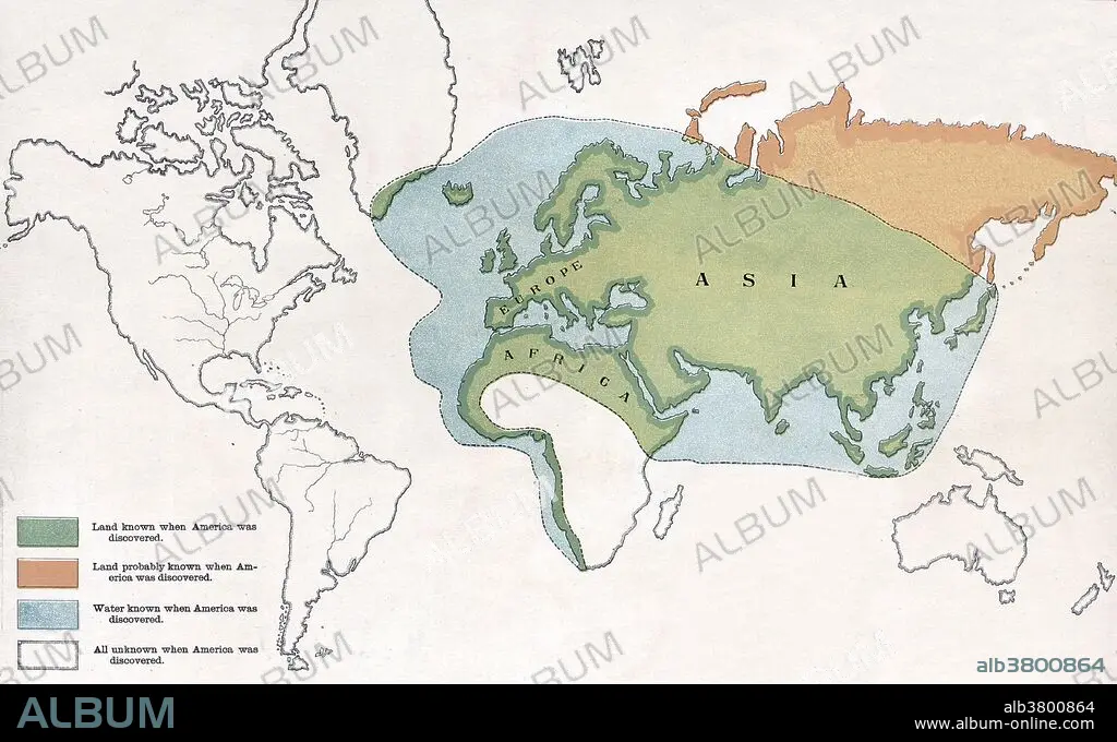
Entitled: "The Earth as known when Columbus sailed." The Age of Discovery is an informal and loosely defined European historical period from the 15th century to the 18th century, marking the time in which extensive overseas exploration emerged as a powerful factor in European culture and globalization. Many lands previously unknown to Europeans were discovered during this period, though most were already inhabited and from the perspective of many non-Europeans it marked the arrival of settlers and invaders from a previously unknown continent. Map appeared in H.C. Robertson's geographic-historical series illustrating the history of America and the United States: from 1492 to the present time.
Entitled: "The Earth as known when Columbus sailed." The Age of Discovery is an informal and loosely defined European historical period from the 15th century to the 18th century, marking the time in which extensive overseas exploration emerged as a powerful factor in European culture and globalization. Many lands previously unknown to Europeans were discovered during this period, though most were already inhabited and from the perspective of many non-Europeans it marked the arrival of settlers and invaders from a previously unknown continent. Map appeared in H.C. Robertson's geographic-historical series illustrating the history of America and the United States: from 1492 to the present time.
Crédito: Album / LOC/Science Source
Autorizaciones: ? Cesión de modelo: No - ? Cesión de propiedad: No
¿Preguntas relacionadas con los derechos?
¿Preguntas relacionadas con los derechos?
Tamaño imagen: 4800 × 2939 px | 40.4 MB
Tamaño impresión: 40.6 × 24.9 cm | 1889.8 × 1157.1 in (300 dpi)
Palabras clave: 1490 • ARTE • ASIGNACIÓN • CARTOGRAFIA • CRISTOBAL COLON • DIBUJO • EXPLORACION • FAMOSA • FAMOSO • FAMOSOS • GEOGRAFIA • GEOGRAFICA • GEOGRAFICO • GRAFICO • HISTORIA • HISTORICO • ILUSTRACION • ILUSTRACIONES • IMPORTANTE • MAPA DEL MUNDO • MAPA MUNDI • MAPA • MAPAMUNDI • NAVEGACION • OBRA DE ARTE • S. -XV
