alb9882067
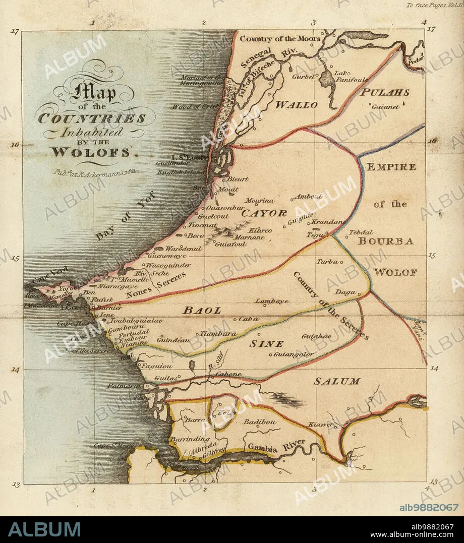
Map of the Jolof or Wolof Empire on the west coast of Africa. Shows Waalo, Kayor, Baol, Sine and Saloum areas, the Senegal and Gambia rivers, and the slave island of Goree. Map of the countres of inhabited by the Wolofs. After Rene Claude Geoffroy de Villeneuves LAfrique, Paris, 1814. Handcoloured stipple copperplate engraving from Frederic Shoberls The World in Miniature: Africa, A description of the manners and customs Moors of the Sahara and of the Negro Nations, R. Ackermann, England, 1821.
| Compartir |
|---|
 Pinterest Pinterest |
 Twitter Twitter |
 Facebook Facebook |
 Copiar enlace Copiar enlace |
 Email Email |
|
Añadir a otro lightbox |
|
Añadir a otro lightbox |


¿Ya tienes cuenta? Iniciar sesión
¿No tienes cuenta? Regístrate
Compra esta imagen.
Selecciona el uso:

Descripción: Ver traducción automática
Map of the Jolof or Wolof Empire on the west coast of Africa. Shows Waalo, Kayor, Baol, Sine and Saloum areas, the Senegal and Gambia rivers, and the slave island of Goree. Map of the countres of inhabited by the Wolofs. After Rene Claude Geoffroy de Villeneuves LAfrique, Paris, 1814. Handcoloured stipple copperplate engraving from Frederic Shoberls The World in Miniature: Africa, A description of the manners and customs Moors of the Sahara and of the Negro Nations, R. Ackermann, England, 1821.
Map of the Jolof or Wolof Empire on the west coast of Africa. Shows Waalo, Kayor, Baol, Sine and Saloum areas, the Senegal and Gambia rivers, and the slave island of Goree. Map of the countres of inhabited by the Wolofs. After Rene Claude Geoffroy de Villeneuves LAfrique, Paris, 1814. Handcoloured stipple copperplate engraving from Frederic Shoberls The World in Miniature: Africa, A description of the manners and customs Moors of the Sahara and of the Negro Nations, R. Ackermann, England, 1821.
Crédito: Album / Florilegius
Autorizaciones: ? Cesión de modelo: No - ? Cesión de propiedad: No
¿Preguntas relacionadas con los derechos?
¿Preguntas relacionadas con los derechos?
Tamaño imagen: 5707 × 6355 px | 103.8 MB
Tamaño impresión: 48.3 × 53.8 cm | 2246.9 × 2502.0 in (300 dpi)
Palabras clave: AFRICA OCCIDENTAL • AFRICA • COLOREADO A MANO • COMERCIO DE ESCLAVOS • COSTA • ESCLAVISMO • ESCLAVITUD • EXPLORACION • GRABADO EN PLACA DE COBRE • MAPA • MAPAS • PULA • PUNTEADO • SENEGAMBIA • TRAFICO DE ESCLAVOS • TRAVESIA • TRAYECTO • VIAJAR • VIAJE • VIAJES
