alb4532038
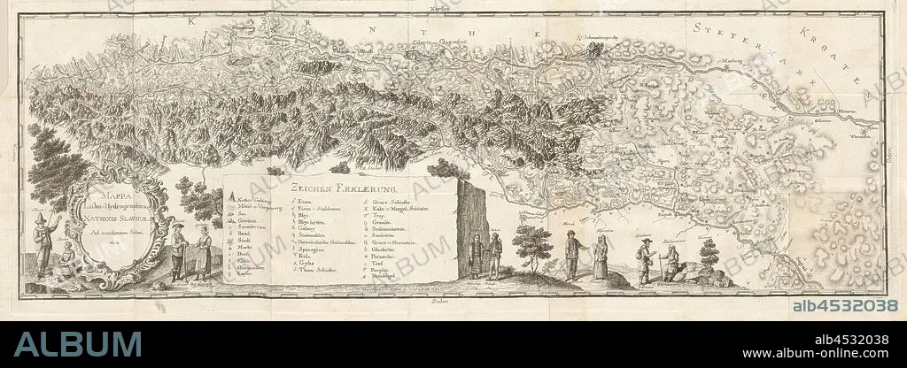
Litho-Hydrographica map ..., Hydrological Map of the Slavic States from the 18th century, signed: signed by Lieber zu Leibach A ° 1782, I. Adam Sc, Fig. 1, p. 184, Lieber (del.); Adam, I. (sculp.), 1778, Balthasar Hacquet, Johann Gottlob Immanuel: Oryctographia carniolica oder physikalische Erdbeschreibung des Herzogthums Krain, Istrien, und zum Theil der benachbarten Länder. Dritter Theil. Leipzig: bey Johann Gottlob Immanuel Breitkopf, 1778-1789.
| Compartir |
|---|
 Pinterest Pinterest |
 Twitter Twitter |
 Facebook Facebook |
 Copiar enlace Copiar enlace |
 Email Email |
|
Añadir a otro lightbox |
|
Añadir a otro lightbox |


¿Ya tienes cuenta? Iniciar sesión
¿No tienes cuenta? Regístrate
Compra esta imagen

Descripción:
Ver traducción automática
Litho-Hydrographica map ..., Hydrological Map of the Slavic States from the 18th century, signed: signed by Lieber zu Leibach A ° 1782, I. Adam Sc, Fig. 1, p. 184, Lieber (del.); Adam, I. (sculp.), 1778, Balthasar Hacquet, Johann Gottlob Immanuel: Oryctographia carniolica oder physikalische Erdbeschreibung des Herzogthums Krain, Istrien, und zum Theil der benachbarten Länder. Dritter Theil. Leipzig: bey Johann Gottlob Immanuel Breitkopf, 1778-1789
Crédito:
Album / quintlox
Autorizaciones:
Modelo: No - Propiedad: No
¿Preguntas relacionadas con los derechos?
¿Preguntas relacionadas con los derechos?
Tamaño imagen:
11019 x 3901 px | 123.0 MB
Tamaño impresión:
93.3 x 33.0 cm | 36.7 x 13.0 in (300 dpi)
Palabras clave:
