alb9514006
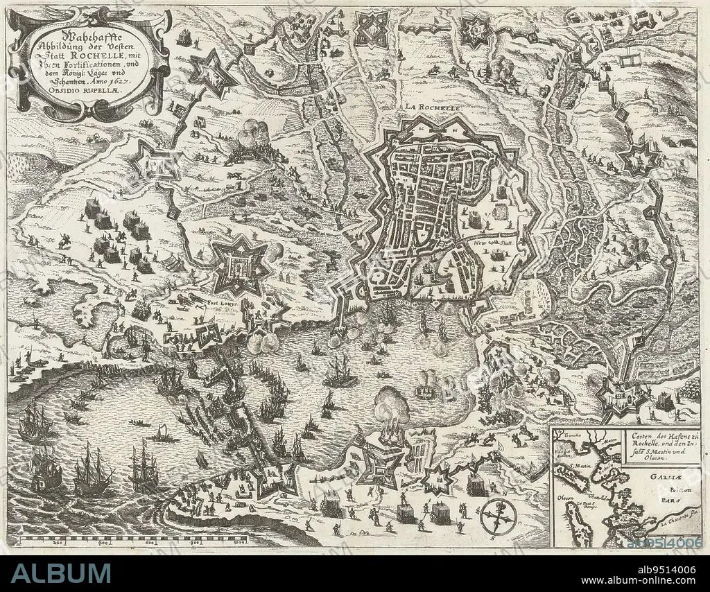
Map of the French coast showing the siege of La Rochelle by the State army and France, September 1627 - October 1628 Surrounding the rebellious city by the French royal troops under Cardinal Richelieu Bottom right an inset with a map of the greater area, Map of the Siege of La Rochelle, 1627-1628 Wahrhaffte Abbildung der Vesten Statt Rochelle, mit Ihren Fortificationen, und dem Knigl: Lger und Schantzen Anno 1627 Obsidio Ruppellae , print maker: anonymous, Claes Jansz. Visscher (II), (workshop of), Germany, 1627 - 1629, paper, etching, h 274 mm × w 350 mm.
| Compartir |
|---|
 Pinterest Pinterest |
 Twitter Twitter |
 Facebook Facebook |
 Copiar enlace Copiar enlace |
 Email Email |
|
Añadir a otro lightbox |
|
Añadir a otro lightbox |


¿Ya tienes cuenta? Iniciar sesión
¿No tienes cuenta? Regístrate
Compra esta imagen.
Selecciona el uso:

Descripción: Ver traducción automática
Map of the French coast showing the siege of La Rochelle by the State army and France, September 1627 - October 1628 Surrounding the rebellious city by the French royal troops under Cardinal Richelieu Bottom right an inset with a map of the greater area, Map of the Siege of La Rochelle, 1627-1628 Wahrhaffte Abbildung der Vesten Statt Rochelle, mit Ihren Fortificationen, und dem Knigl: Lger und Schantzen Anno 1627 Obsidio Ruppellae , print maker: anonymous, Claes Jansz. Visscher (II), (workshop of), Germany, 1627 - 1629, paper, etching, h 274 mm × w 350 mm
Map of the French coast showing the siege of La Rochelle by the State army and France, September 1627 - October 1628 Surrounding the rebellious city by the French royal troops under Cardinal Richelieu Bottom right an inset with a map of the greater area, Map of the Siege of La Rochelle, 1627-1628 Wahrhaffte Abbildung der Vesten Statt Rochelle, mit Ihren Fortificationen, und dem Knigl: Lger und Schantzen Anno 1627 Obsidio Ruppellae , print maker: anonymous, Claes Jansz. Visscher (II), (workshop of), Germany, 1627 - 1629, paper, etching, h 274 mm × w 350 mm
Crédito: Album / quintlox
Autorizaciones: ? Cesión de modelo: No - ? Cesión de propiedad: No
¿Preguntas relacionadas con los derechos?
¿Preguntas relacionadas con los derechos?
Tamaño imagen: 4761 × 3722 px | 50.7 MB
Tamaño impresión: 40.3 × 31.5 cm | 1874.4 × 1465.4 in (300 dpi)
