alb4082277
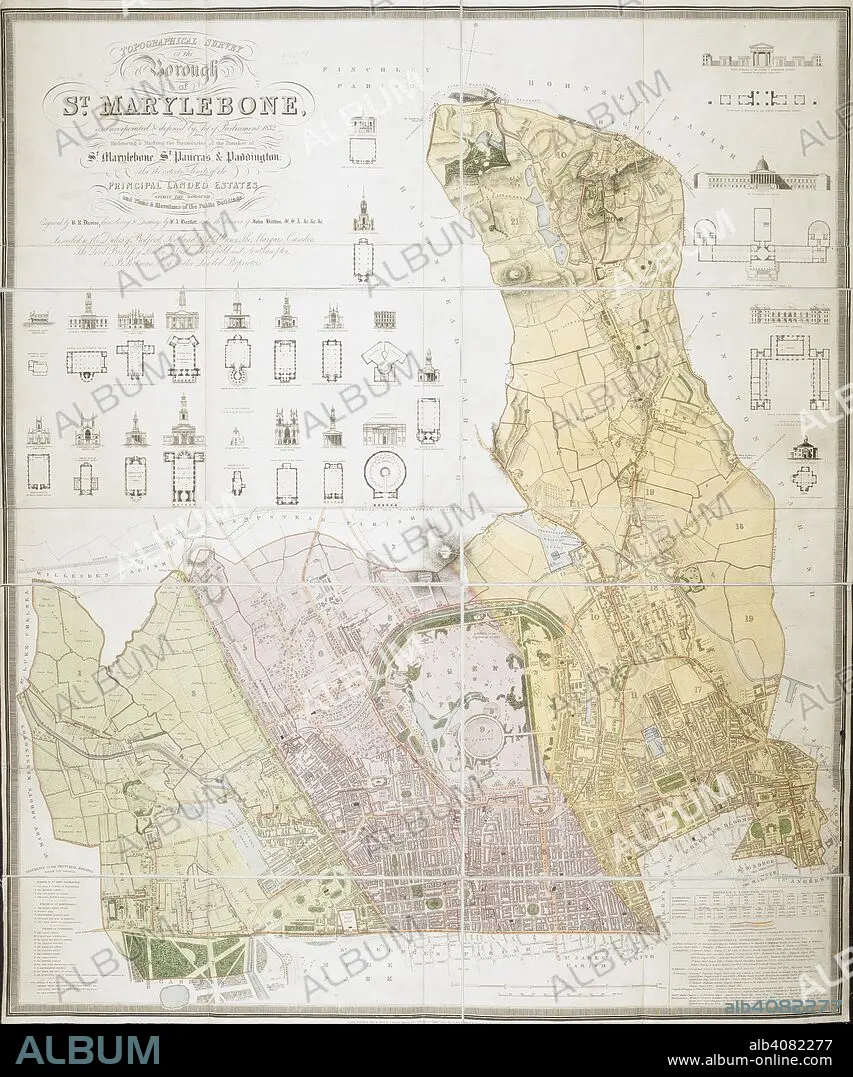
BENJAMIN REES DAVIES. Topographical survey of the borough of St. Marylebone, as incorporated & defined by Act of Parliament 1832. : Embracing & marking the boundaries of the parishes of St. Marylebone, St. Pancras, & Paddington, also the extents & limits of the principal landed estates within the borough, and plans & elevations of the public buildings Boundaries outlined in colour; map coloured and numbered for reference with a key at bottom left and note on parishes at bottom right. Relief shown by hachures. Supplies elevations and ground plans of prominent buildings. . Topographical survey of the borough of St. Marylebone, as incorporated & defined by Act of Parliament 1832. : Embracing & marking the boundaries of the parishes of St. Marylebone, St. Pancras, & Paddington, also the extents & limits of the principal landed estates within the borough, and plans & elevations of the public buildings / Engraved by B.R. Davies from surveys & drawings by F.A. Bartlett under the direction of John Britton F.S.A. &c. &c. &c. London : Published by J. Britton, Burton Str., J. Taylor, 30 Upper Gower Str. & B.R. Davies, 16 George Str. Euston Squ:, June 25, 1837. Source: Maps Crace Port.1.
| Compartir |
|---|
 Pinterest Pinterest |
 Twitter Twitter |
 Facebook Facebook |
 Copiar enlace Copiar enlace |
 Email Email |
|
Añadir a otro lightbox |
|
Añadir a otro lightbox |


¿Ya tienes cuenta? Iniciar sesión
¿No tienes cuenta? Regístrate
Compra esta imagen.
Selecciona el uso:

Descripción: Ver traducción automática
Topographical survey of the borough of St. Marylebone, as incorporated & defined by Act of Parliament 1832. : Embracing & marking the boundaries of the parishes of St. Marylebone, St. Pancras, & Paddington, also the extents & limits of the principal landed estates within the borough, and plans & elevations of the public buildings Boundaries outlined in colour; map coloured and numbered for reference with a key at bottom left and note on parishes at bottom right. Relief shown by hachures. Supplies elevations and ground plans of prominent buildings. . Topographical survey of the borough of St. Marylebone, as incorporated & defined by Act of Parliament 1832. : Embracing & marking the boundaries of the parishes of St. Marylebone, St. Pancras, & Paddington, also the extents & limits of the principal landed estates within the borough, and plans & elevations of the public buildings / Engraved by B.R. Davies from surveys & drawings by F.A. Bartlett under the direction of John Britton F.S.A. &c. &c. &c. London : Published by J. Britton, Burton Str., J. Taylor, 30 Upper Gower Str. & B.R. Davies, 16 George Str. Euston Squ:, June 25, 1837. Source: Maps Crace Port.1.
Topographical survey of the borough of St. Marylebone, as incorporated & defined by Act of Parliament 1832. : Embracing & marking the boundaries of the parishes of St. Marylebone, St. Pancras, & Paddington, also the extents & limits of the principal landed estates within the borough, and plans & elevations of the public buildings Boundaries outlined in colour; map coloured and numbered for reference with a key at bottom left and note on parishes at bottom right. Relief shown by hachures. Supplies elevations and ground plans of prominent buildings. . Topographical survey of the borough of St. Marylebone, as incorporated & defined by Act of Parliament 1832. : Embracing & marking the boundaries of the parishes of St. Marylebone, St. Pancras, & Paddington, also the extents & limits of the principal landed estates within the borough, and plans & elevations of the public buildings / Engraved by B.R. Davies from surveys & drawings by F.A. Bartlett under the direction of John Britton F.S.A. &c. &c. &c. London : Published by J. Britton, Burton Str., J. Taylor, 30 Upper Gower Str. & B.R. Davies, 16 George Str. Euston Squ:, June 25, 1837. Source: Maps Crace Port.1.
Crédito: Album / British Library
Tamaño imagen: 6362 × 7639 px | 139.0 MB
Tamaño impresión: 53.9 × 64.7 cm | 2504.7 × 3007.5 in (300 dpi)
Palabras clave: ALBION • CARTOGRAFIA • CARTOGRAFICO • COLOR • COLORES • COLORIDO • DAVIES, BENJAMIN REES • EUROPA OCCIDENTAL • EUROPA • GRAN BRETAÑA • INGLATERRA • ISLAS BRITANICAS • LONDON • LONDRES • MAPA • MAPAS • REINO UNIDO • S. XIX • SIGLO XIX
