alb4284602
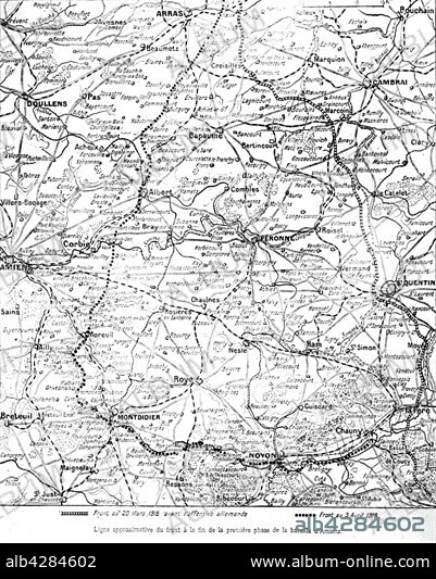
Map pf the Battle of Amiens
| Compartir |
|---|
 Pinterest Pinterest |
 Twitter Twitter |
 Facebook Facebook |
 Copiar enlace Copiar enlace |
 Email Email |
|
Añadir a otro lightbox |
|
Añadir a otro lightbox |


¿Ya tienes cuenta? Iniciar sesión
¿No tienes cuenta? Regístrate
Compra esta imagen.
Selecciona el uso:

Título:
Map pf the Battle of Amiens
Descripción:
Ver traducción automática
First World War. . Approximate front line at the end of the first phase of the Battle of Amiens.. The drawn to scale map indicates the line on 20th March 1918 and the dotted line indicates the front to 3 April 1918.
Crédito:
Album / Photo12/Archives Snark
Autorizaciones:
Modelo: No - Propiedad: No
¿Preguntas relacionadas con los derechos?
¿Preguntas relacionadas con los derechos?
Tamaño imagen:
3965 x 4943 px | 56.1 MB
Tamaño impresión:
33.6 x 41.9 cm | 13.2 x 16.5 in (300 dpi)
Palabras clave:
ALBERT • CAMBRAI • FRANCIA • GUERRA MUNDIAL I • MAPA • PRIMERA GUERRA MUNDIAL • SAINT-QUENTIN • SIGLO XX • WW1
