alb4390577
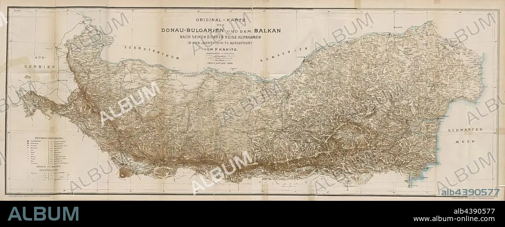
Original map of Danube-Bulgaria and the Balkans according to his own travel photographs taken in the years 1870-1874 by F. Kanitz, Map of the ethnologist Felix Philip Kanitz, Signed: Lith. U., Print by K. K. Hof- u., State Printing House, Fig. 121, p. 368, Kanitz, Felix Philipp (fec.); Kaiserlich-Königliche Hof- und Staatsdruckerei Wien (lith. u. gedr.), 1879, F. Kanitz: Donau-Bulgarien und der Balkan: historisch-geographisch-ethnographische Reisestudien aus den Jahren 1860-1879. Leipzig: Verlagsbuchhandlung von Hermann Fries, 1879-1880.
| Compartir |
|---|
 Pinterest Pinterest |
 Twitter Twitter |
 Facebook Facebook |
 Copiar enlace Copiar enlace |
 Email Email |
|
Añadir a otro lightbox |
|
Añadir a otro lightbox |


¿Ya tienes cuenta? Iniciar sesión
¿No tienes cuenta? Regístrate
Compra esta imagen.
Selecciona el uso:

Descripción: Ver traducción automática
Original map of Danube-Bulgaria and the Balkans according to his own travel photographs taken in the years 1870-1874 by F. Kanitz, Map of the ethnologist Felix Philip Kanitz, Signed: Lith. U., Print by K. K. Hof- u., State Printing House, Fig. 121, p. 368, Kanitz, Felix Philipp (fec.); Kaiserlich-Königliche Hof- und Staatsdruckerei Wien (lith. u. gedr.), 1879, F. Kanitz: Donau-Bulgarien und der Balkan: historisch-geographisch-ethnographische Reisestudien aus den Jahren 1860-1879. Leipzig: Verlagsbuchhandlung von Hermann Fries, 1879-1880
Original map of Danube-Bulgaria and the Balkans according to his own travel photographs taken in the years 1870-1874 by F. Kanitz, Map of the ethnologist Felix Philip Kanitz, Signed: Lith. U., Print by K. K. Hof- u., State Printing House, Fig. 121, p. 368, Kanitz, Felix Philipp (fec.); Kaiserlich-Königliche Hof- und Staatsdruckerei Wien (lith. u. gedr.), 1879, F. Kanitz: Donau-Bulgarien und der Balkan: historisch-geographisch-ethnographische Reisestudien aus den Jahren 1860-1879. Leipzig: Verlagsbuchhandlung von Hermann Fries, 1879-1880
Crédito: Album / quintlox
Autorizaciones: ? Cesión de modelo: No - ? Cesión de propiedad: No
¿Preguntas relacionadas con los derechos?
¿Preguntas relacionadas con los derechos?
Tamaño imagen: 9000 × 3574 px | 92.0 MB
Tamaño impresión: 76.2 × 30.3 cm | 3543.3 × 1407.1 in (300 dpi)
