alb3835242
Before and After Thailand Tsunami
| Compartir |
|---|
 Pinterest Pinterest |
 Twitter Twitter |
 Facebook Facebook |
 Copiar enlace Copiar enlace |
 Email Email |
|
Añadir a otro lightbox |
|
Añadir a otro lightbox |


¿Ya tienes cuenta? Iniciar sesión
¿No tienes cuenta? Regístrate
Compra esta imagen.
Selecciona el uso:

Título:
Before and After Thailand Tsunami
Descripción:
Ver traducción automática
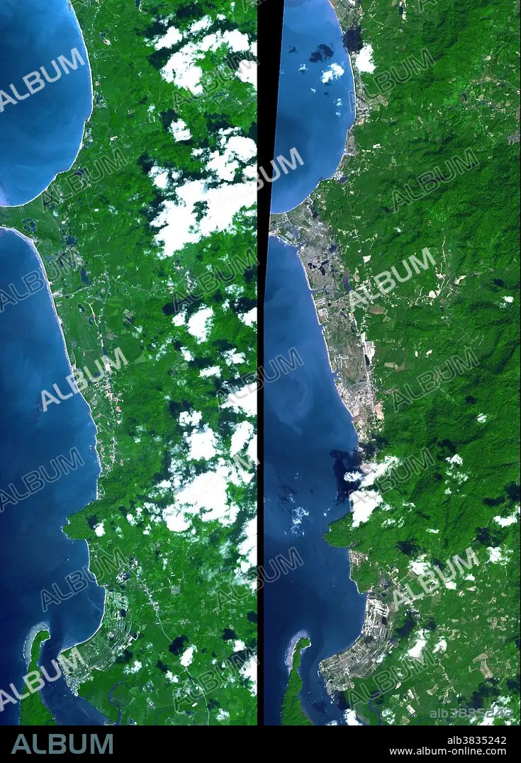
The island of Phuket on the Indian Ocean coast of Thailand is a major tourist destination and was also in the path of the tsunami that washed ashore on December 26, 2004, resulting in a heavy loss of life. These simulated natural color ASTER images show a 27 kilometer (17 mile) long stretch of coast north of the Phuket airport on December 31 (right), along with an image acquired two years earlier (left). The changes along the coast are obvious where the vegetation has been stripped away. These images are being used to create damage assessment maps for the U.S. Agency for International Development (USAID) Office of Foreign Disaster Assistance. With its 14 spectral bands from the visible to the thermal infrared wavelength region, and its high spatial resolution of 15 to 90 meters (about 50 to 300 feet), ASTER images Earth to map and monitor the changing surface of our planet. ASTER is one of five Earth-observing instruments launched December 18, 1999, on NASA's Terra satellite. The broad
Crédito:
Album / Science Source / NASA/GSFC/METI/ERSDAC/JAROS, and U.S./Japan ASTER Science Team
Autorizaciones:
Modelo: No - Propiedad: No
¿Preguntas relacionadas con los derechos?
¿Preguntas relacionadas con los derechos?
Tamaño imagen:
1320 x 1840 px | 6.9 MB
Tamaño impresión:
11.2 x 15.6 cm | 4.4 x 6.1 in (300 dpi)
Palabras clave:
AEREO • ANTES Y DESPUES • ASIA • ASIATICO • COSTA • DESASTRE NATURAL • DESASTRE • FOTOGRAFIA AEREA • GEOLOGIA • HISTORICO • LITORAL • OCEANO INDICO • SUDESTE DE ASIA • TAILANDIA • TOPOGRAFIA • TRAGEDIA • TSUNAMI
