alb9451594
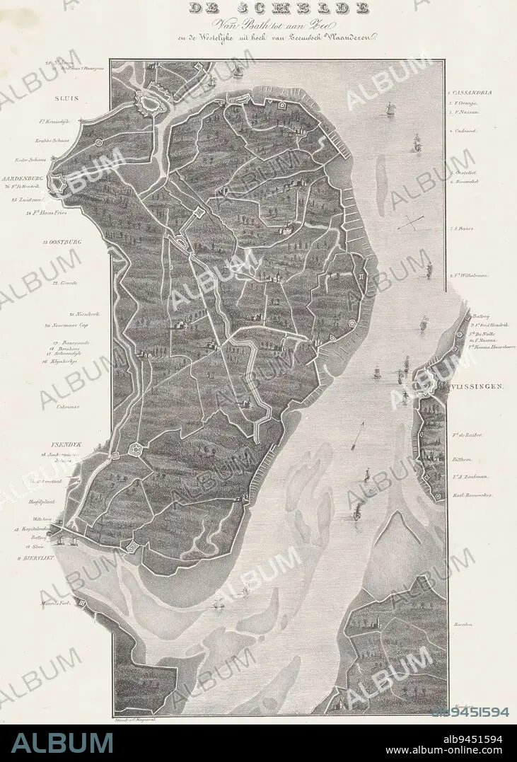
Map of the course of the Scheldt from Koudorp (bottom) to Sluis (top), at the time of the siege of Antwerp in December 1832. Along the river the various entrenchments and forts are indicated. The legend on either side of the representation 1-28. Map in two sheets, of which this is the upper part, Loop van de Schelde van Fort Bath tot zee (upper sheet), 1832 De Schelde Van Bath tot aan Zee. en de Westelijke uit hoek van Zeeuwsch Vlaanderen (title on object), print maker: Willem Charles Magnenat, (mentioned on object), publisher: Frans Buffa en Zonen, (mentioned on object), print maker: Netherlands, publisher: Amsterdam, 1833, paper, h 543 mm × w 380 mm.
| Compartir |
|---|
 Pinterest Pinterest |
 Twitter Twitter |
 Facebook Facebook |
 Copiar enlace Copiar enlace |
 Email Email |
|
Añadir a otro lightbox |
|
Añadir a otro lightbox |


¿Ya tienes cuenta? Iniciar sesión
¿No tienes cuenta? Regístrate
Compra esta imagen.
Selecciona el uso:

Descripción: Ver traducción automática
Map of the course of the Scheldt from Koudorp (bottom) to Sluis (top), at the time of the siege of Antwerp in December 1832. Along the river the various entrenchments and forts are indicated. The legend on either side of the representation 1-28. Map in two sheets, of which this is the upper part, Loop van de Schelde van Fort Bath tot zee (upper sheet), 1832 De Schelde Van Bath tot aan Zee. en de Westelijke uit hoek van Zeeuwsch Vlaanderen (title on object), print maker: Willem Charles Magnenat, (mentioned on object), publisher: Frans Buffa en Zonen, (mentioned on object), print maker: Netherlands, publisher: Amsterdam, 1833, paper, h 543 mm × w 380 mm
Map of the course of the Scheldt from Koudorp (bottom) to Sluis (top), at the time of the siege of Antwerp in December 1832. Along the river the various entrenchments and forts are indicated. The legend on either side of the representation 1-28. Map in two sheets, of which this is the upper part, Loop van de Schelde van Fort Bath tot zee (upper sheet), 1832 De Schelde Van Bath tot aan Zee. en de Westelijke uit hoek van Zeeuwsch Vlaanderen (title on object), print maker: Willem Charles Magnenat, (mentioned on object), publisher: Frans Buffa en Zonen, (mentioned on object), print maker: Netherlands, publisher: Amsterdam, 1833, paper, h 543 mm × w 380 mm
Crédito: Album / quintlox
Autorizaciones: ? Cesión de modelo: No - ? Cesión de propiedad: No
¿Preguntas relacionadas con los derechos?
¿Preguntas relacionadas con los derechos?
Tamaño imagen: 3690 × 5167 px | 54.5 MB
Tamaño impresión: 31.2 × 43.7 cm | 1452.8 × 2034.3 in (300 dpi)
