alb9527371
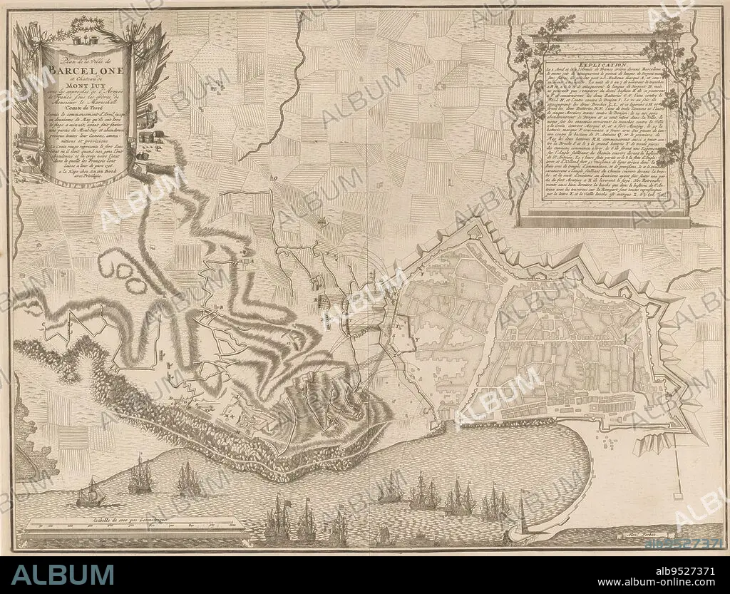
Map of the siege of Barcelona by the French and Spaniards from April onwards but relieved by the Allies on 12 May 1706, Map of the siege of Barcelona, 1706 Plan de la ville de Barcelona and Chateau de Mont Juy with the approvals (...), print maker: Jan van Call (II), (mentioned on object), intermediary draughtsman: Alexander Forbes, (mentioned on object), publisher: Anna Beeck, (mentioned on object), The Hague, 1706, paper, engraving, etching, h 455 mm × w 596 mm.
| Partager |
|---|
 Pinterest Pinterest |
 Twitter Twitter |
 Facebook Facebook |
 Copier le lien Copier le lien |
 Email Email |
|
Ajouter à une autre Lightbox |
|
Ajouter à une autre Lightbox |


Avez-vous déjà un compte? S'identifier
Vous n'avez pas de compte ? S'inscrire
Acheter cette image.
Sélectionnez l'usage:

Légende: Voir la traduction automatique
Map of the siege of Barcelona by the French and Spaniards from April onwards but relieved by the Allies on 12 May 1706, Map of the siege of Barcelona, 1706 Plan de la ville de Barcelona and Chateau de Mont Juy with the approvals (...), print maker: Jan van Call (II), (mentioned on object), intermediary draughtsman: Alexander Forbes, (mentioned on object), publisher: Anna Beeck, (mentioned on object), The Hague, 1706, paper, engraving, etching, h 455 mm × w 596 mm
Map of the siege of Barcelona by the French and Spaniards from April onwards but relieved by the Allies on 12 May 1706, Map of the siege of Barcelona, 1706 Plan de la ville de Barcelona and Chateau de Mont Juy with the approvals (...), print maker: Jan van Call (II), (mentioned on object), intermediary draughtsman: Alexander Forbes, (mentioned on object), publisher: Anna Beeck, (mentioned on object), The Hague, 1706, paper, engraving, etching, h 455 mm × w 596 mm
Personnalités: JAN VAN CALL
Crédit: Album / quintlox
Autorisations: ? Autorisation de modèle: Non - ? Autorisation de propriété: Non
Questions sur les droits?
Questions sur les droits?
Taille de l'image: 5087 × 3874 px | 56.4 MB
Taille d'impression: 43.1 × 32.8 cm | 2002.8 × 1525.2 in (300 dpi)
Mots clés: BARCELONE • CARTE (GEOGRAPHIE) • CARTE GEOGRAPHIQUE • CARTE • DESSIN PLANS • FRANÁAIS • FRANÁAISE • FRANÇAIS • FRAVURE • GRAVURE • JAN VAN CALL • OBJET • PAPIER • PLAN (CARTOGRAPHIE) • PLANS
