alb15431405
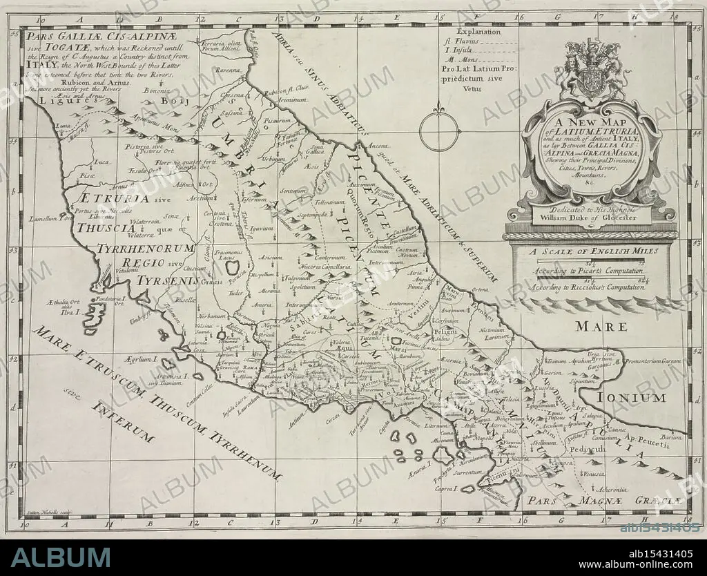
A new map of Latium, Etruria, and as much of ancient Itally, as lay between Gallia Cisalpina and Græcia Magna, shewing their principal divisions, cities, towns, rivers, mountains &c., 1700, Sheldonian Theatre, Additional title: Latium, and Etruria., Date Issued: 1700, Place: Oxford :, Publisher: Printed at theTheater, Atlases, British, Geography, Ancient, Maps in education, England, Maps, Ancient lands unfold, Cities rise amidst the hills, History's terrain.
| Partager |
|---|
 Pinterest Pinterest |
 Twitter Twitter |
 Facebook Facebook |
 Copier le lien Copier le lien |
 Email Email |
|
Ajouter à une autre Lightbox |
|
Ajouter à une autre Lightbox |


Avez-vous déjà un compte? S'identifier
Vous n'avez pas de compte ? S'inscrire
Acheter cette image.
Sélectionnez l'usage:

Légende:
Voir la traduction automatique
A new map of Latium, Etruria, and as much of ancient Itally, as lay between Gallia Cisalpina and Græcia Magna, shewing their principal divisions, cities, towns, rivers, mountains &c., 1700, Sheldonian Theatre, Additional title: Latium, and Etruria., Date Issued: 1700, Place: Oxford :, Publisher: Printed at theTheater, Atlases, British, Geography, Ancient, Maps in education, England, Maps, Ancient lands unfold, Cities rise amidst the hills, History's terrain.
Crédit:
Album / quintlox
Autorisations:
Modèle: Non - Propriété: Non
Questions sur les droits?
Questions sur les droits?
Taille de l'image:
4794 x 3656 px | 50.1 MB
Taille d'impression:
40.6 x 31.0 cm | 16.0 x 12.2 in (300 dpi)
Mots clés:
ANCIEN • ANGLETARRE • ANGLETERE • ANGLETERRE • ANTIQUE • ATLAS (LIVRE) • CARTE (GEOGRAPHIE) • CARTE GEOGRAPHIQUE • CARTE • CITE • COURS • CULTURE • DESSIN PLANS • ÉCOLES • EDUCATION ECOLE • EDUCATION • ÉDUQUER • ENSEIGNANT • ENSEIGNEMENT • FLEUVE • FORMATION • GEOGRAPHIE • GRANDE BERTAGNE • GRANDE BRETAGNE • GRANDE-BRETAGNE • INGLATERRA • INSTITUTEURS • INSTRUCTION (ENSEIGNEMENT) • INSTRUCTION • MAITRES ECOLE • OXFORD • PEDAGOGIE • PLAN (CARTOGRAPHIE) • PLANS • PROFESSEUR • RIO • RIVIÈRE FLEUVE • RIVIERE • RIVIRE • RIVIRE • ROYAUME UNI • ROYAUME-UNI • VILE • VILLE
