alb3546293
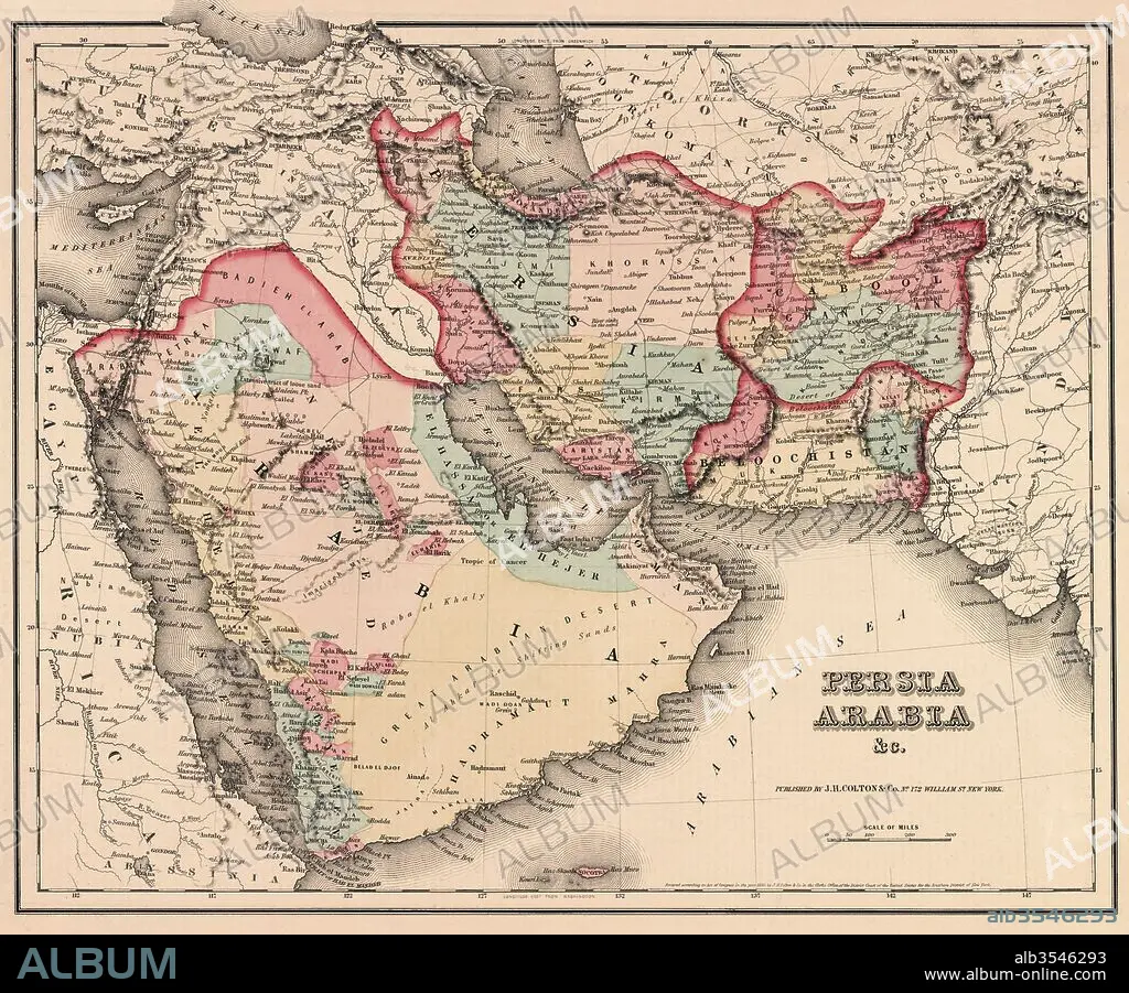
The Middle East in the mid 19th century
| Partager |
|---|
 Pinterest Pinterest |
 Twitter Twitter |
 Facebook Facebook |
 Copier le lien Copier le lien |
 Email Email |
|
Ajouter à une autre Lightbox |
|
Ajouter à une autre Lightbox |


Avez-vous déjà un compte? S'identifier
Vous n'avez pas de compte ? S'inscrire
Acheter cette image.
Sélectionnez l'usage:

Titre: The Middle East in the mid 19th century
Légende: Voir la traduction automatique
The Middle East in the mid 19th century. Persia, Arabia etc. as it was circa 1850. From Colton's General Atlas, edition of 1857.
The Middle East in the mid 19th century. Persia, Arabia etc. as it was circa 1850. From Colton's General Atlas, edition of 1857.
Crédit: Album / Universal Images Group / Universal History Archive
Autorisations: ? Autorisation de modèle: Non - ? Autorisation de propriété: Non
Questions sur les droits?
Questions sur les droits?
Taille de l'image: 5151 × 4264 px | 62.8 MB
Taille d'impression: 43.6 × 36.1 cm | 2028.0 × 1678.7 in (300 dpi)
Mots clés: ANT. OR.: IRAK • ANT. OR.: IRAN • ANT. OR.: SYRIE • ARABIE • ART PERSAN • ART SYRIEN • CARTE (GEOGRAPHIE) • CARTE GEOGRAPHIQUE • CARTE • CARTOGRAPHIE • COULEUR • DESSIN PLANS • EST • GÉNÉRAL CONFÉDÉRÉ • GENERAL • GÉNÉRAUX • GNERAL • HISOIRE • HISTOIRE • IRAK • IRAK, ANT. OR. • IRAN • IRAN, ANT. OR. • LIBAN • LIBAN? ? • MYTHES: PERSES • ORIENT • PALESTINE • PERSAN • PERSE • PERSES • PERSES, MYTHES • PLAN (CARTOGRAPHIE) • PLANS • PROCHE-ORIENT • SCIENCE: CARTOGRAPHIE • SYRIE • SYRIE, ANT. OR. • SYRIEN • TURQUIE • XIXE SIÈCLE
