alb3547306
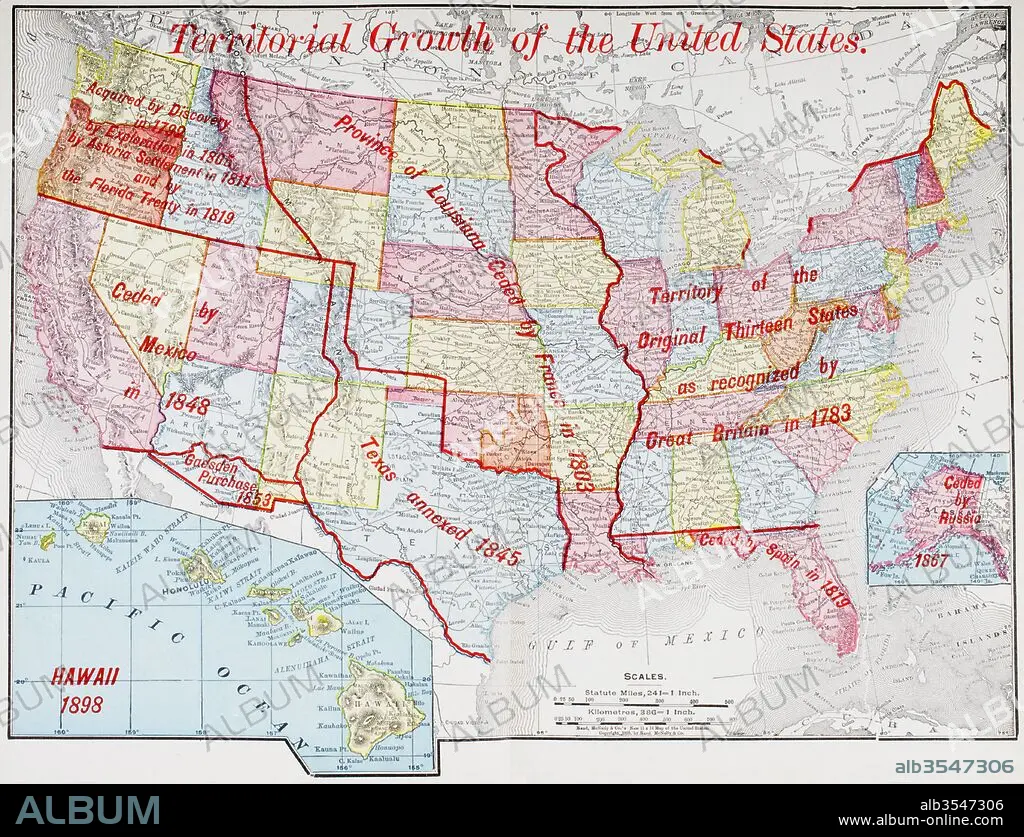
Map from 1898 showing the territorial growth of the United States of America
| Partager |
|---|
 Pinterest Pinterest |
 Twitter Twitter |
 Facebook Facebook |
 Copier le lien Copier le lien |
 Email Email |
|
Ajouter à une autre Lightbox |
|
Ajouter à une autre Lightbox |


Avez-vous déjà un compte? S'identifier
Vous n'avez pas de compte ? S'inscrire
Acheter cette image.
Sélectionnez l'usage:

Titre: Map from 1898 showing the territorial growth of the United States of America
Légende: Voir la traduction automatique
Map from 1898 showing the territorial growth of the United States of America. From The History of Our Country, published 1900
Map from 1898 showing the territorial growth of the United States of America. From The History of Our Country, published 1900
Crédit: Album / Universal Images Group / Universal History Archive
Autorisations: ? Autorisation de modèle: Non - ? Autorisation de propriété: Non
Questions sur les droits?
Questions sur les droits?
Taille de l'image: 4783 × 3664 px | 50.1 MB
Taille d'impression: 40.5 × 31.0 cm | 1883.1 × 1442.5 in (300 dpi)
Mots clés: AMÉRCAIN • AMERICAIN (ETATS-UNIS) • AMERICAIN (USA) • AMÉRICAIN • AMÉRICAINE • AMÉRICIAN • AMÉRICIANE • AMERIQUE • AMERIQUE, CONTINENT • ANGLETARRE • ANGLETERE • ANGLETERRE • ANNEXION • CARTE (GEOGRAPHIE) • CARTE GEOGRAPHIQUE • CARTE • CONTINENT AMERIQUE • CROISSANCE • DANOIS • DANOISE • DESSIN PLANS • ESPAGNE • ESPAGNOL • ÉTAS UNIS • ÉTAS-UNIS • ETATS UNIS • ETATS-UNIS • FRANCE • GEOGRAPHIE • GRANDE BERTAGNE • GRANDE BRETAGNE • GRANDE-BRETAGNE • HISOIRE • HISTOIRE • ILLUSTRATION • INGLATERRA • MEXICAIN • MEXICAINE • MEXICO • MEXIQUE • ORIGINAL • ORIGINEL • PLAN (CARTOGRAPHIE) • PLANS • POUSSE • ROYAUME UNI • ROYAUME • ROYAUME-UNI • ROYAUTÉ • RUSSE • RUSSIE • TREIZE • U. S. A. • XIXE SIÈCLE • ŽTATS-UNIS
